Guomaying geodata
Guomaying (Qinghai) is a seat of a fourth-order administrative division; located in China in Asia/Shanghai (GMT+8) time zone. In our database, there are 1268 cities with bigger population. Compared to other cities in China, 76.8% of cities are located further ↓South; 93.7% of cities are located further →East and 97.1% of cities have lower elevation than Guomaying. Note1


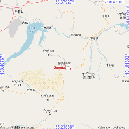
Guomaying GPS coordinates[2]
35° 48' 40.032" North, 101° 6' 38.844" East
| Map corner | latitude | longitude |
|---|---|---|
| Upper-left | 36.37927°, | 100.40767° |
| Center: | 35.81112°, | 101.11079° |
| Lower-right: | 35.23888°, | 101.81392° |
| Map W x H: | 126.8×126.8 km | = 78.8×78.8mi |
| max Lat: | 53.31946° ⇑23.2% North |
| Guomaying: | 35.81112° |
| min Lat: | ⇓76.8% South 18.22056° |
| min Long | Guomaying | max Long |
| 75.07348° | 101.11079° | 134.28917° |
| W 6.3%⇐ | ⇒93.7% E |
Elevation
Elevation of Guomaying is 3095 m = 10154 ft, and this is 2610.2 m = 8564 ft above average elevation for this country.
| Max E: |
5622 m = 18445 ft | 2.9% |
| Guomaying | 3095 m 10154 ft | |
| Avg. | 484.8 m = 1591 ft | |
Min E: |
-3 m = -10 ft | 97.1% |
See also: China elevation on elevation.city.
Geographical zone
Guomaying is located in North temperate zone (between Tropic of Cancer and the Arctic Circle). Distance of this Northern Tropic circle is 1375.9 km =854.9 mi to South.| Distance of | km | miles | from Guomaying |
|---|---|---|---|
| North Pole | 6025.2 | 3743.9 | to North |
| Arctic Circle | 3419.4 | 2124.7 | to North |
| Tropic Cancer | 1375.9 | 854.9 | to South |
| Equator | 3981.8 | 2474.2 | to South |


Nearby cities:
15 places around Guomaying: (largest is in red/bold)
• Changmu
44.6 km =27.7 mi,  90°
90°
• Donggou
37.4 km =23.2 mi,  73°
73°
• Garang
61.5 km =38.2 mi,  41°
41°
• Hedong
40.8 km =25.4 mi,  50°
50°
• Hexi
34.7 km =21.6 mi, 44°
• Heyin
38.6 km =24 mi, 47°
• Lhakangtang
34.8 km =21.6 mi,  13°
13°
• Longyangxia
40.2 km =25 mi,  331°
331°
• Mangqu
40.9 km =25.4 mi,  232°
232°
• Quedantang
49.4 km =30.7 mi,  248°
248°
• Shagou
19.6 km =12.2 mi,  306°
306°
• Sumdo
36.3 km =22.6 mi,  206°
206°
• Tiegai
56 km =34.8 mi,  317°
317°
• Wangjia
48.8 km =30.3 mi,  196°
196°
• Xinjie
25.9 km =16.1 mi,  113°
113°
Sources, notices
• [Note1] Compared only with cities in China existing in our database
• [Src1] Map data: © OpenStreetMap contributors (CC-BY-SA)
• [Src2] Other city data from geonames.org with taken over terms of usage.
• [Src3] Geographical zone / Annual Mean Temperature by Robert A. Rohde @ Wikipedia
