Longyangxia geodata
Longyangxia (Qinghai) is a seat of a fourth-order administrative division; located in China in Asia/Shanghai (GMT+8) time zone. In our database, there are 1268 cities with bigger population. Compared to other cities in China, 77.5% of cities are located further ↓South; 93.9% of cities are located further →East and 96.1% of cities have lower elevation than Longyangxia. Note1


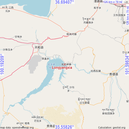
Longyangxia GPS coordinates[2]
36° 7' 41.592" North, 100° 53' 42.756" East
| Map corner | latitude | longitude |
|---|---|---|
| Upper-left | 36.69407°, | 100.19209° |
| Center: | 36.12822°, | 100.89521° |
| Lower-right: | 35.55826°, | 101.59834° |
| Map W x H: | 126.3×126.3 km | = 78.5×78.5mi |
| max Lat: | 53.31946° ⇑22.5% North |
| Longyangxia: | 36.12822° |
| min Lat: | ⇓77.5% South 18.22056° |
| min Long | Longyangxia | max Long |
| 75.07348° | 100.89521° | 134.28917° |
| W 6.1%⇐ | ⇒93.9% E |
Elevation
Elevation of Longyangxia is 2583 m = 8474 ft, and this is 2098.2 m = 6884 ft above average elevation for this country.
| Max E: |
5622 m = 18445 ft | 3.9% |
| Longyangxia | 2583 m 8474 ft | |
| Avg. | 484.8 m = 1591 ft | |
Min E: |
-3 m = -10 ft | 96.1% |
See also: China elevation on elevation.city.
Geographical zone
Longyangxia is located in North temperate zone (between Tropic of Cancer and the Arctic Circle). Distance of this Northern Tropic circle is 1411.2 km =876.9 mi to South.| Distance of | km | miles | from Longyangxia |
|---|---|---|---|
| North Pole | 5990 | 3722 | to North |
| Arctic Circle | 3384.1 | 2102.8 | to North |
| Tropic Cancer | 1411.2 | 876.9 | to South |
| Equator | 4017.1 | 2496.1 | to South |


Nearby cities:
15 places around Longyangxia: (largest is in red/bold)
• Daotanghe
30.7 km =19.1 mi,  11°
11°
• Donggou
60.6 km =37.7 mi,  114°
114°
• Gandi
56.6 km =35.2 mi,  302°
302°
• Guomaying
40.2 km =25 mi,  151°
151°
• Hedong
51.5 km =32 mi,  100°
100°
• Hexi
45 km =28 mi, 103°
• Heyin
48.8 km =30.3 mi, 101°
• Lhakangtang
27.3 km =17 mi,  92°
92°
• Qabqa
30.5 km =19 mi, 303°
• Quedantang
59.4 km =36.9 mi,  206°
206°
• Riyue
51.1 km =31.8 mi,  26°
26°
• Sazhubxi
57.5 km =35.7 mi,  287°
287°
• Shagou
23.8 km =14.8 mi,  171°
171°
• Tiegai
19.3 km =12 mi, 288°
• Tumba
30.1 km =18.7 mi,  338°
338°
Sources, notices
• [Note1] Compared only with cities in China existing in our database
• [Src1] Map data: © OpenStreetMap contributors (CC-BY-SA)
• [Src2] Other city data from geonames.org with taken over terms of usage.
• [Src3] Geographical zone / Annual Mean Temperature by Robert A. Rohde @ Wikipedia
