Shagou geodata
Shagou (Qinghai) is a seat of a fourth-order administrative division; located in China in Asia/Shanghai (GMT+8) time zone. In our database, there are 1268 cities with bigger population. Compared to other cities in China, 77% of cities are located further ↓South; 93.8% of cities are located further →East and 96.3% of cities have lower elevation than Shagou. Note1


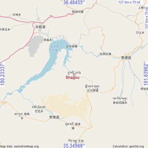
Shagou GPS coordinates[2]
35° 55' 1.812" North, 100° 56' 11.364" East
| Map corner | latitude | longitude |
|---|---|---|
| Upper-left | 36.48455°, | 100.23337° |
| Center: | 35.91717°, | 100.93649° |
| Lower-right: | 35.34569°, | 101.63962° |
| Map W x H: | 126.6×126.6 km | = 78.7×78.7mi |
| max Lat: | 53.31946° ⇑23% North |
| Shagou: | 35.91717° |
| min Lat: | ⇓77% South 18.22056° |
| min Long | Shagou | max Long |
| 75.07348° | 100.93649° | 134.28917° |
| W 6.2%⇐ | ⇒93.8% E |
Elevation
Elevation of Shagou is 2735 m = 8973 ft, and this is 2250.2 m = 7383 ft above average elevation for this country.
| Max E: |
5622 m = 18445 ft | 3.7% |
| Shagou | 2735 m 8973 ft | |
| Avg. | 484.8 m = 1591 ft | |
Min E: |
-3 m = -10 ft | 96.3% |
See also: China elevation on elevation.city.
Geographical zone
Shagou is located in North temperate zone (between Tropic of Cancer and the Arctic Circle). Distance of this Northern Tropic circle is 1387.7 km =862.3 mi to South.| Distance of | km | miles | from Shagou |
|---|---|---|---|
| North Pole | 6013.4 | 3736.6 | to North |
| Arctic Circle | 3407.6 | 2117.4 | to North |
| Tropic Cancer | 1387.7 | 862.3 | to South |
| Equator | 3993.6 | 2481.5 | to South |


Nearby cities:
15 places around Shagou: (largest is in red/bold)
• Daotanghe
53.6 km =33.3 mi,  2°
2°
• Donggou
51.6 km =32.1 mi,  91°
91°
• Guomaying
19.6 km =12.2 mi,  126°
126°
• Hedong
49.2 km =30.6 mi,  73°
73°
• Hexi
42.1 km =26.2 mi, 72°
• Heyin
46.5 km =28.9 mi, 72°
• Lhakangtang
32.4 km =20.1 mi,  46°
46°
• Longyangxia
23.8 km =14.8 mi,  351°
351°
• Mangqu
40.4 km =25.1 mi,  204°
204°
• Qabqa
49.8 km =30.9 mi,  324°
324°
• Quedantang
42.4 km =26.3 mi,  225°
225°
• Sumdo
44.3 km =27.5 mi,  180°
180°
• Tiegai
36.9 km =22.9 mi, 323°
• Tumba
53.5 km =33.2 mi,  343°
343°
• Xinjie
45.3 km =28.1 mi,  119°
119°
Sources, notices
• [Note1] Compared only with cities in China existing in our database
• [Src1] Map data: © OpenStreetMap contributors (CC-BY-SA)
• [Src2] Other city data from geonames.org with taken over terms of usage.
• [Src3] Geographical zone / Annual Mean Temperature by Robert A. Rohde @ Wikipedia
