Gaoqiao geodata
Gaoqiao (Hubei) is a seat of a fourth-order administrative division; located in China in Asia/Shanghai (GMT+8) time zone. In our database, there are 1268 cities with bigger population. Compared to other cities in China, 56.5% of cities are located further ↓South; 68.9% of cities are located further →East and 82.7% of cities have lower elevation than Gaoqiao. Note1


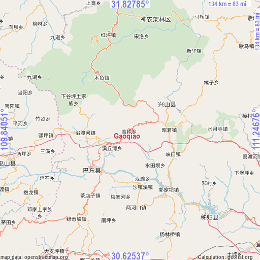
Gaoqiao GPS coordinates[2]
31° 13' 42.672" North, 110° 32' 37.068" East
| Map corner | latitude | longitude |
|---|---|---|
| Upper-left | 31.82785°, | 109.84051° |
| Center: | 31.22852°, | 110.54363° |
| Lower-right: | 30.62537°, | 111.24676° |
| Map W x H: | 133.7×133.7 km | = 83.1×83.1mi |
| max Lat: | 53.31946° ⇑43.5% North |
| Gaoqiao: | 31.22852° |
| min Lat: | ⇓56.5% South 18.22056° |
| min Long | Gaoqiao | max Long |
| 75.07348° | 110.54363° | 134.28917° |
| W 31.1%⇐ | ⇒68.9% E |
Elevation
Elevation of Gaoqiao is 832 m = 2730 ft, and this is 347.2 m = 1139 ft above average elevation for this country.
| Max E: |
5622 m = 18445 ft | 17.3% |
| Gaoqiao | 832 m 2730 ft | |
| Avg. | 484.8 m = 1591 ft | |
Min E: |
-3 m = -10 ft | 82.7% |
See also: China elevation on elevation.city.
Geographical zone
Gaoqiao is located in North temperate zone (between Tropic of Cancer and the Arctic Circle). Distance of this Northern Tropic circle is 866.4 km =538.4 mi to South.| Distance of | km | miles | from Gaoqiao |
|---|---|---|---|
| North Pole | 6534.8 | 4060.5 | to North |
| Arctic Circle | 3928.9 | 2441.3 | to North |
| Tropic Cancer | 866.4 | 538.4 | to South |
| Equator | 3472.3 | 2157.6 | to South |


Nearby cities:
15 places around Gaoqiao: (largest is in red/bold)
• Gaoyang
20.8 km =12.9 mi,  89°
89°
• Guandukou
30.7 km =19.1 mi,  226°
226°
• Gufu
23.1 km =14.4 mi,  49°
49°
• Guizhou
29.3 km =18.2 mi,  151°
151°
• Huangliang
27.1 km =16.8 mi,  81°
81°
• Jianyangping
29.3 km =18.2 mi,  111°
111°
• Muyu
30.9 km =19.2 mi,  331°
331°
• Nanyang
15.3 km =9.5 mi, 51°
• Shazhenxi
30.5 km =19 mi,  169°
169°
• Shuitianba
22.7 km =14.1 mi, 145°
• Xiakou
25.4 km =15.8 mi,  118°
118°
• Xietan
25.2 km =15.7 mi,  163°
163°
• Xinling
31.2 km =19.4 mi,  223°
223°
• Xiqiuwan
13.4 km =8.3 mi, 225°
• Yanduhe
24.1 km =15 mi,  269°
269°
Sources, notices
• [Note1] Compared only with cities in China existing in our database
• [Src1] Map data: © OpenStreetMap contributors (CC-BY-SA)
• [Src2] Other city data from geonames.org with taken over terms of usage.
• [Src3] Geographical zone / Annual Mean Temperature by Robert A. Rohde @ Wikipedia
