Gaoyang geodata
Gaoyang (Hubei) is a seat of a fourth-order administrative division; located in China in Asia/Shanghai (GMT+8) time zone. In our database, there are 1268 cities with bigger population. Compared to other cities in China, 56.5% of cities are located further ↓South; 68% of cities are located further →East and 52% of cities have lower elevation than Gaoyang. Note1


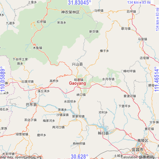
Gaoyang GPS coordinates[2]
31° 13' 52.104" North, 110° 45' 43.236" East
| Map corner | latitude | longitude |
|---|---|---|
| Upper-left | 31.83045°, | 110.05889° |
| Center: | 31.23114°, | 110.76201° |
| Lower-right: | 30.628°, | 111.46514° |
| Map W x H: | 133.7×133.7 km | = 83.1×83.1mi |
| max Lat: | 53.31946° ⇑43.5% North |
| Gaoyang: | 31.23114° |
| min Lat: | ⇓56.5% South 18.22056° |
| min Long | Gaoyang | max Long |
| 75.07348° | 110.76201° | 134.28917° |
| W 32%⇐ | ⇒68% E |
Elevation
Elevation of Gaoyang is 181 m = 594 ft, and this is 303.8 m = 997 ft below average elevation for this country.
| Max E: |
5622 m = 18445 ft | 48% |
| Avg. | 484.8 m = 1591 ft | |
| Gaoyang | 181 m = 594 ft | |
Min E: |
-3 m = -10 ft | 52% |
See also: China elevation on elevation.city.
Geographical zone
Gaoyang is located in North temperate zone (between Tropic of Cancer and the Arctic Circle). Distance of this Northern Tropic circle is 866.7 km =538.5 mi to South.| Distance of | km | miles | from Gaoyang |
|---|---|---|---|
| North Pole | 6534.5 | 4060.3 | to North |
| Arctic Circle | 3928.6 | 2441.1 | to North |
| Tropic Cancer | 866.7 | 538.5 | to South |
| Equator | 3472.6 | 2157.8 | to South |


Nearby cities:
15 places around Gaoyang: (largest is in red/bold)
• Gaoqiao
20.8 km =12.9 mi,  269°
269°
• Gufu
14.9 km =9.3 mi,  347°
347°
• Guizhou
26.9 km =16.7 mi,  194°
194°
• Guojiaba
34.5 km =21.4 mi, 185°
• Huangliang
7.1 km =4.4 mi,  58°
58°
• Jianyangping
12.8 km =8 mi,  149°
149°
• Nanyang
12.8 km =8 mi,  316°
316°
• Quyuan
33.5 km =20.8 mi,  169°
169°
• Shazhenxi
34 km =21.1 mi,  206°
206°
• Shuitianba
20.8 km =12.9 mi,  202°
202°
• Shuiyuesi
24 km =14.9 mi,  88°
88°
• Xiakou
12.4 km =7.7 mi, 172°
• Xietan
28 km =17.4 mi, 209°
• Xiqiuwan
31.9 km =19.8 mi,  252°
252°
• Zhenzi
32 km =19.9 mi,  39°
39°
Sources, notices
• [Note1] Compared only with cities in China existing in our database
• [Src1] Map data: © OpenStreetMap contributors (CC-BY-SA)
• [Src2] Other city data from geonames.org with taken over terms of usage.
• [Src3] Geographical zone / Annual Mean Temperature by Robert A. Rohde @ Wikipedia
