Huangliang geodata
Huangliang (Hubei) is a seat of a fourth-order administrative division; located in China in Asia/Shanghai (GMT+8) time zone. In our database, there are 1268 cities with bigger population. Compared to other cities in China, 56.7% of cities are located further ↓South; 67.8% of cities are located further →East and 83.4% of cities have lower elevation than Huangliang. Note1


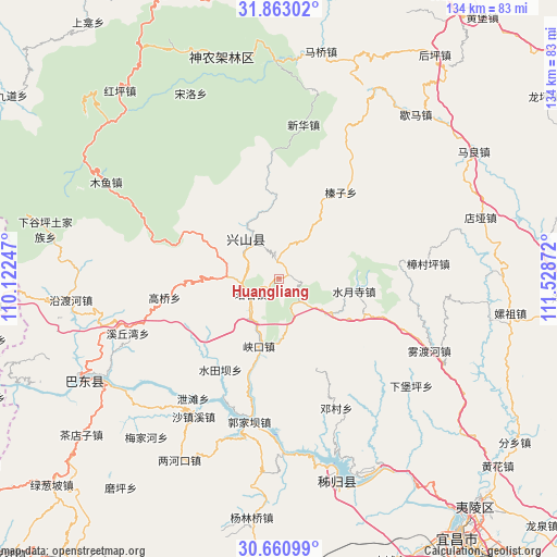
Huangliang GPS coordinates[2]
31° 15' 50.112" North, 110° 49' 32.124" East
| Map corner | latitude | longitude |
|---|---|---|
| Upper-left | 31.86302°, | 110.12247° |
| Center: | 31.26392°, | 110.82559° |
| Lower-right: | 30.66099°, | 111.52872° |
| Map W x H: | 133.7×133.7 km | = 83.1×83.1mi |
| max Lat: | 53.31946° ⇑43.3% North |
| Huangliang: | 31.26392° |
| min Lat: | ⇓56.7% South 18.22056° |
| min Long | Huangliang | max Long |
| 75.07348° | 110.82559° | 134.28917° |
| W 32.2%⇐ | ⇒67.8% E |
Elevation
Elevation of Huangliang is 874 m = 2867 ft, and this is 389.2 m = 1277 ft above average elevation for this country.
| Max E: |
5622 m = 18445 ft | 16.6% |
| Huangliang | 874 m 2867 ft | |
| Avg. | 484.8 m = 1591 ft | |
Min E: |
-3 m = -10 ft | 83.4% |
See also: China elevation on elevation.city.
Geographical zone
Huangliang is located in North temperate zone (between Tropic of Cancer and the Arctic Circle). Distance of this Northern Tropic circle is 870.3 km =540.8 mi to South.| Distance of | km | miles | from Huangliang |
|---|---|---|---|
| North Pole | 6530.8 | 4058 | to North |
| Arctic Circle | 3925 | 2438.9 | to North |
| Tropic Cancer | 870.3 | 540.8 | to South |
| Equator | 3476.2 | 2160 | to South |


Nearby cities:
15 places around Huangliang: (largest is in red/bold)
• Gaoqiao
27.1 km =16.8 mi,  261°
261°
• Gaoyang
7.1 km =4.4 mi,  238°
238°
• Gufu
14.2 km =8.8 mi,  319°
319°
• Guizhou
32.4 km =20.1 mi,  203°
203°
• Guojiaba
39.1 km =24.3 mi,  193°
193°
• Jianyangping
14.6 km =9.1 mi,  177°
177°
• Nanyang
15.9 km =9.9 mi,  290°
290°
• Quyuan
36.5 km =22.7 mi, 179°
• Shuitianba
26.8 km =16.7 mi,  211°
211°
• Shuiyuesi
18.1 km =11.2 mi,  98°
98°
• Xiakou
16.5 km =10.3 mi, 195°
• Xietan
34.3 km =21.3 mi,  215°
215°
• Xiqiuwan
38.8 km =24.1 mi,  249°
249°
• Zhangcunping
36.2 km =22.5 mi,  84°
84°
• Zhenzi
25.4 km =15.8 mi,  34°
34°
Sources, notices
• [Note1] Compared only with cities in China existing in our database
• [Src1] Map data: © OpenStreetMap contributors (CC-BY-SA)
• [Src2] Other city data from geonames.org with taken over terms of usage.
• [Src3] Geographical zone / Annual Mean Temperature by Robert A. Rohde @ Wikipedia
