Gaocheng geodata
Gaocheng (Jiangsu) is a seat of a fourth-order administrative division; located in China in Asia/Shanghai (GMT+8) time zone. In our database, there are 1268 cities with bigger population. Compared to other cities in China, 58.1% of cities are located further ↓South; 80.6% of cities are located further ←West and 91.2% of cities have higher elevation than Gaocheng. Note1


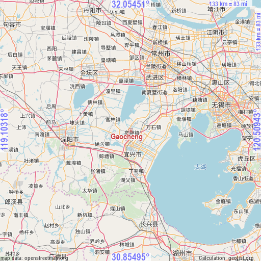
Gaocheng GPS coordinates[2]
31° 27' 23.94" North, 119° 48' 22.68" East
| Map corner | latitude | longitude |
|---|---|---|
| Upper-left | 32.05451°, | 119.10318° |
| Center: | 31.45665°, | 119.8063° |
| Lower-right: | 30.85495°, | 120.50943° |
| Map W x H: | 133.4×133.4 km | = 82.9×82.9mi |
| max Lat: | 53.31946° ⇑41.9% North |
| Gaocheng: | 31.45665° |
| min Lat: | ⇓58.1% South 18.22056° |
| min Long | Gaocheng | max Long |
| 75.07348° | 119.8063° | 134.28917° |
| W 80.6%⇐ | ⇒19.4% E |
Elevation
Elevation of Gaocheng is 9 m = 30 ft, and this is 475.8 m = 1561 ft below average elevation for this country.
| Max E: |
5622 m = 18445 ft | 91.2% |
| Avg. | 484.8 m = 1591 ft | |
| Gaocheng | 9 m = 30 ft | |
Min E: |
-3 m = -10 ft | 8.8% |
See also: China elevation on elevation.city.
Geographical zone
Gaocheng is located in North temperate zone (between Tropic of Cancer and the Arctic Circle). Distance of this Northern Tropic circle is 891.7 km =554.1 mi to South.| Distance of | km | miles | from Gaocheng |
|---|---|---|---|
| North Pole | 6509.4 | 4044.8 | to North |
| Arctic Circle | 3903.5 | 2425.5 | to North |
| Tropic Cancer | 891.7 | 554.1 | to South |
| Equator | 3497.7 | 2173.4 | to South |


Nearby cities:
15 places around Gaocheng: (largest is in red/bold)
• Fangqiao
13.1 km =8.1 mi,  110°
110°
• Guanlin
10.4 km =6.5 mi,  300°
300°
• Heqiao
8.1 km =5 mi,  67°
67°
• Huangli
21.8 km =13.5 mi,  335°
335°
• Liangpeng
14 km =8.7 mi, 336°
• Qianhuang
21.4 km =13.3 mi,  43°
43°
• Qiting
5.6 km =3.5 mi, 113°
• Wanshi
11.7 km =7.3 mi,  79°
79°
• Xinjian
18.3 km =11.4 mi,  309°
309°
• Xinjie
11.1 km =6.9 mi,  208°
208°
• Xinzhuang
15 km =9.3 mi,  139°
139°
• Xushe
16.2 km =10.1 mi,  245°
245°
• Yangxiang
20.9 km =13 mi,  276°
276°
• Yicheng
10.8 km =6.7 mi,  172°
172°
• Zhoutie
18 km =11.2 mi,  96°
96°
Sources, notices
• [Note1] Compared only with cities in China existing in our database
• [Src1] Map data: © OpenStreetMap contributors (CC-BY-SA)
• [Src2] Other city data from geonames.org with taken over terms of usage.
• [Src3] Geographical zone / Annual Mean Temperature by Robert A. Rohde @ Wikipedia
