Huangli geodata
Huangli (Jiangsu) is a seat of a fourth-order administrative division; located in China in Asia/Shanghai (GMT+8) time zone. In our database, there are 1268 cities with bigger population. Compared to other cities in China, 59.2% of cities are located further ↓South; 80% of cities are located further ←West and 89.9% of cities have higher elevation than Huangli. Note1


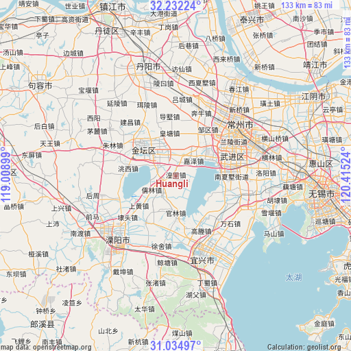
Huangli GPS coordinates[2]
31° 38' 7.908" North, 119° 42' 43.596" East
| Map corner | latitude | longitude |
|---|---|---|
| Upper-left | 32.23224°, | 119.00899° |
| Center: | 31.63553°, | 119.71211° |
| Lower-right: | 31.03497°, | 120.41524° |
| Map W x H: | 133.1×133.1 km | = 82.7×82.7mi |
| max Lat: | 53.31946° ⇑40.8% North |
| Huangli: | 31.63553° |
| min Lat: | ⇓59.2% South 18.22056° |
| min Long | Huangli | max Long |
| 75.07348° | 119.71211° | 134.28917° |
| W 80%⇐ | ⇒20% E |
Elevation
Elevation of Huangli is 10 m = 33 ft, and this is 474.8 m = 1558 ft below average elevation for this country.
| Max E: |
5622 m = 18445 ft | 89.9% |
| Avg. | 484.8 m = 1591 ft | |
| Huangli | 10 m = 33 ft | |
Min E: |
-3 m = -10 ft | 10.1% |
See also: China elevation on elevation.city.
Geographical zone
Huangli is located in North temperate zone (between Tropic of Cancer and the Arctic Circle). Distance of this Northern Tropic circle is 911.6 km =566.4 mi to South.| Distance of | km | miles | from Huangli |
|---|---|---|---|
| North Pole | 6489.5 | 4032.4 | to North |
| Arctic Circle | 3883.6 | 2413.2 | to North |
| Tropic Cancer | 911.6 | 566.4 | to South |
| Equator | 3517.5 | 2185.7 | to South |


Nearby cities:
15 places around Huangli: (largest is in red/bold)
• Guanlin
14.6 km =9.1 mi,  180°
180°
• Huangtang
16.6 km =10.3 mi,  352°
352°
• Jiaze
9 km =5.6 mi,  50°
50°
• Jincheng
17.8 km =11.1 mi,  312°
312°
• Liangpeng
7.8 km =4.8 mi,  155°
155°
• Nanxiashu
21.5 km =13.4 mi,  91°
91°
• Niutang
20.4 km =12.7 mi,  57°
57°
• Rulin
10.4 km =6.5 mi,  239°
239°
• Shanghuang
17.1 km =10.6 mi,  234°
234°
• Xinjian
9.7 km =6 mi,  212°
212°
• Yangxiang
21.1 km =13.1 mi, 213°
• Yaotang
9.8 km =6.1 mi,  339°
339°
• Yong’an
7.4 km =4.6 mi,  271°
271°
• Zhiqian
21.2 km =13.2 mi, 265°
• Zouqu
21.6 km =13.4 mi,  34°
34°
Sources, notices
• [Note1] Compared only with cities in China existing in our database
• [Src1] Map data: © OpenStreetMap contributors (CC-BY-SA)
• [Src2] Other city data from geonames.org with taken over terms of usage.
• [Src3] Geographical zone / Annual Mean Temperature by Robert A. Rohde @ Wikipedia
