Tiantang geodata
Tiantang (Guizhou) is a seat of a fourth-order administrative division; located in China in Asia/Shanghai (GMT+8) time zone. In our database, there are 1268 cities with bigger population. Compared to other cities in China, 72.9% of cities are located further ↑North; 78.3% of cities are located further →East and 78.3% of cities have lower elevation than Tiantang. Note1


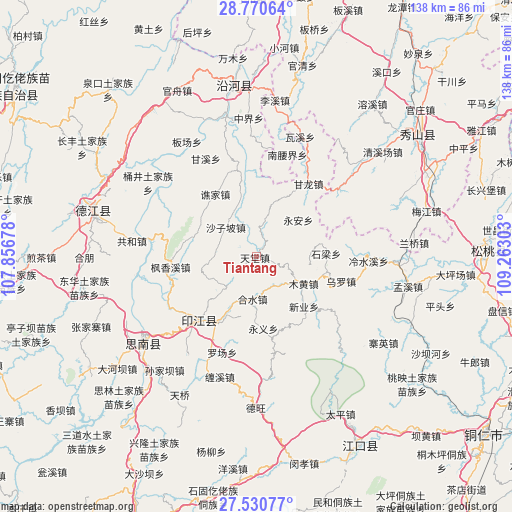
Tiantang GPS coordinates[2]
28° 9' 9" North, 108° 33' 35.64" East
| Map corner | latitude | longitude |
|---|---|---|
| Upper-left | 28.77064°, | 107.85678° |
| Center: | 28.1525°, | 108.5599° |
| Lower-right: | 27.53077°, | 109.26303° |
| Map W x H: | 137.9×137.9 km | = 85.7×85.7mi |
| max Lat: | 53.31946° ⇑72.9% North |
| Tiantang: | 28.1525° |
| min Lat: | ⇓27.1% South 18.22056° |
| min Long | Tiantang | max Long |
| 75.07348° | 108.5599° | 134.28917° |
| W 21.7%⇐ | ⇒78.3% E |
Elevation
Elevation of Tiantang is 626 m = 2054 ft, and this is 141.2 m = 463 ft above average elevation for this country.
| Max E: |
5622 m = 18445 ft | 21.7% |
| Tiantang | 626 m 2054 ft | |
| Avg. | 484.8 m = 1591 ft | |
Min E: |
-3 m = -10 ft | 78.3% |
See also: China elevation on elevation.city.
Geographical zone
Tiantang is located in North temperate zone (between Tropic of Cancer and the Arctic Circle). Distance of this Northern Tropic circle is 524.3 km =325.8 mi to South.| Distance of | km | miles | from Tiantang |
|---|---|---|---|
| North Pole | 6876.8 | 4273 | to North |
| Arctic Circle | 4270.9 | 2653.8 | to North |
| Tropic Cancer | 524.3 | 325.8 | to South |
| Equator | 3130.3 | 1945.1 | to South |


Nearby cities:
15 places around Tiantang: (largest is in red/bold)
• Banxi
12.6 km =7.8 mi,  225°
225°
• Daoba
10.1 km =6.3 mi,  14°
14°
• Eling
23 km =14.3 mi,  222°
222°
• Fengxiangxi
23.3 km =14.5 mi,  263°
263°
• Ganlong
24.1 km =15 mi,  35°
35°
• Heshui
11.3 km =7 mi,  184°
184°
• Langxi
17.6 km =10.9 mi,  206°
206°
• Muhuang
14.6 km =9.1 mi,  119°
119°
• Qiaojia
20.1 km =12.5 mi,  326°
326°
• Shanshu
15.3 km =9.5 mi,  252°
252°
• Shazipo
11.4 km =7.1 mi,  313°
313°
• Shiliang
18.9 km =11.7 mi,  83°
83°
• Wuluo
23.8 km =14.8 mi,  106°
106°
• Xinye
18.2 km =11.3 mi,  133°
133°
• Yong’an
15 km =9.3 mi,  48°
48°
Sources, notices
• [Note1] Compared only with cities in China existing in our database
• [Src1] Map data: © OpenStreetMap contributors (CC-BY-SA)
• [Src2] Other city data from geonames.org with taken over terms of usage.
• [Src3] Geographical zone / Annual Mean Temperature by Robert A. Rohde @ Wikipedia
