Shiliang geodata
Shiliang (Guizhou) is a seat of a fourth-order administrative division; located in China in Asia/Shanghai (GMT+8) time zone. In our database, there are 1268 cities with bigger population. Compared to other cities in China, 72.7% of cities are located further ↑North; 77.4% of cities are located further →East and 82.7% of cities have lower elevation than Shiliang. Note1


Shiliang GPS coordinates[2]
28° 10' 22.368" North, 108° 45' 6.192" East
| Map corner | latitude | longitude |
|---|---|---|
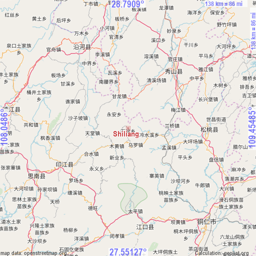
| Upper-left | 28.7909°, | 108.0486° |
| Center: | 28.17288°, | 108.75172° |
| Lower-right: | 27.55127°, | 109.45485° |
| Map W x H: | 137.8×137.8 km | = 85.6×85.6mi |
| max Lat: | 53.31946° ⇑72.7% North |
| Shiliang: | 28.17288° |
| min Lat: | ⇓27.3% South 18.22056° |
| min Long | Shiliang | max Long |
| 75.07348° | 108.75172° | 134.28917° |
| W 22.6%⇐ | ⇒77.4% E |
Elevation
Elevation of Shiliang is 829 m = 2720 ft, and this is 344.2 m = 1129 ft above average elevation for this country.
| Max E: |
5622 m = 18445 ft | 17.3% |
| Shiliang | 829 m 2720 ft | |
| Avg. | 484.8 m = 1591 ft | |
Min E: |
-3 m = -10 ft | 82.7% |
See also: China elevation on elevation.city.
Geographical zone
Shiliang is located in North temperate zone (between Tropic of Cancer and the Arctic Circle). Distance of this Northern Tropic circle is 526.6 km =327.2 mi to South.| Distance of | km | miles | from Shiliang |
|---|---|---|---|
| North Pole | 6874.5 | 4271.6 | to North |
| Arctic Circle | 4268.6 | 2652.4 | to North |
| Tropic Cancer | 526.6 | 327.2 | to South |
| Equator | 3132.5 | 1946.4 | to South |


Nearby cities:
15 places around Shiliang: (largest is in red/bold)
• Aikou
18.1 km =11.2 mi,  16°
16°
• Dalu
20.1 km =12.5 mi,  99°
99°
• Daoba
18 km =11.2 mi,  294°
294°
• Ganlong
18 km =11.2 mi,  344°
344°
• Heshui
24 km =14.9 mi,  235°
235°
• Lanqiao
23.8 km =14.8 mi,  85°
85°
• Lengshuixi
11.9 km =7.4 mi,  106°
106°
• Mengxi
24.3 km =15.1 mi, 114°
• Muhuang
11.3 km =7 mi,  212°
212°
• Tang’ao
25.2 km =15.7 mi,  13°
13°
• Tiantang
18.9 km =11.7 mi,  263°
263°
• Wuluo
9.7 km =6 mi,  155°
155°
• Xinye
15.9 km =9.9 mi,  200°
200°
• Yong’an
10.7 km =6.6 mi,  315°
315°
• Zhongling
24.5 km =15.2 mi,  55°
55°
Sources, notices
• [Note1] Compared only with cities in China existing in our database
• [Src1] Map data: © OpenStreetMap contributors (CC-BY-SA)
• [Src2] Other city data from geonames.org with taken over terms of usage.
• [Src3] Geographical zone / Annual Mean Temperature by Robert A. Rohde @ Wikipedia
