Daoba geodata
Daoba (Guizhou) is a seat of a fourth-order administrative division; located in China in Asia/Shanghai (GMT+8) time zone. In our database, there are 1268 cities with bigger population. Compared to other cities in China, 72% of cities are located further ↑North; 78.2% of cities are located further →East and 81.6% of cities have lower elevation than Daoba. Note1


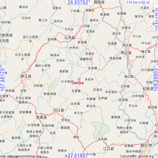
Daoba GPS coordinates[2]
28° 14' 24.684" North, 108° 35' 5.64" East
| Map corner | latitude | longitude |
|---|---|---|
| Upper-left | 28.85782°, | 107.88178° |
| Center: | 28.24019°, | 108.5849° |
| Lower-right: | 27.61897°, | 109.28803° |
| Map W x H: | 137.7×137.7 km | = 85.6×85.6mi |
| max Lat: | 53.31946° ⇑72% North |
| Daoba: | 28.24019° |
| min Lat: | ⇓28% South 18.22056° |
| min Long | Daoba | max Long |
| 75.07348° | 108.5849° | 134.28917° |
| W 21.8%⇐ | ⇒78.2% E |
Elevation
Elevation of Daoba is 770 m = 2526 ft, and this is 285.2 m = 936 ft above average elevation for this country.
| Max E: |
5622 m = 18445 ft | 18.4% |
| Daoba | 770 m 2526 ft | |
| Avg. | 484.8 m = 1591 ft | |
Min E: |
-3 m = -10 ft | 81.6% |
See also: China elevation on elevation.city.
Geographical zone
Daoba is located in North temperate zone (between Tropic of Cancer and the Arctic Circle). Distance of this Northern Tropic circle is 534.1 km =331.9 mi to South.| Distance of | km | miles | from Daoba |
|---|---|---|---|
| North Pole | 6867 | 4267 | to North |
| Arctic Circle | 4261.2 | 2647.8 | to North |
| Tropic Cancer | 534.1 | 331.9 | to South |
| Equator | 3140 | 1951.1 | to South |


Nearby cities:
15 places around Daoba: (largest is in red/bold)
• Aikou
23.5 km =14.6 mi,  65°
65°
• Banxi
21.8 km =13.5 mi,  211°
211°
• Ganlong
15.2 km =9.4 mi,  49°
49°
• Ganxi
23.1 km =14.4 mi,  316°
316°
• Heshui
21.3 km =13.2 mi,  189°
189°
• Muhuang
19.8 km =12.3 mi,  148°
148°
• Nanyaojie
18.7 km =11.6 mi,  18°
18°
• Qiaojia
15.2 km =9.4 mi,  297°
297°
• Shanshu
22.2 km =13.8 mi,  229°
229°
• Shazipo
10.9 km =6.8 mi,  260°
260°
• Shiliang
18 km =11.2 mi,  114°
114°
• Tiantang
10.1 km =6.3 mi, 194°
• Waxi
24.4 km =15.2 mi, 22°
• Xiaojing
21.2 km =13.2 mi,  357°
357°
• Yong’an
8.8 km =5.5 mi,  88°
88°
Sources, notices
• [Note1] Compared only with cities in China existing in our database
• [Src1] Map data: © OpenStreetMap contributors (CC-BY-SA)
• [Src2] Other city data from geonames.org with taken over terms of usage.
• [Src3] Geographical zone / Annual Mean Temperature by Robert A. Rohde @ Wikipedia
