Gangmei geodata
Gangmei (Guangdong) is a seat of a fourth-order administrative division; located in China in Asia/Shanghai (GMT+8) time zone. In our database, there are 1268 cities with bigger population. Compared to other cities in China, 97.2% of cities are located further ↑North; 63.8% of cities are located further →East and 82.1% of cities have higher elevation than Gangmei. Note1


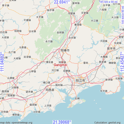
Gangmei GPS coordinates[2]
22° 2' 38.004" North, 111° 45' 4.104" East
| Map corner | latitude | longitude |
|---|---|---|
| Upper-left | 22.6941°, | 111.04802° |
| Center: | 22.04389°, | 111.75114° |
| Lower-right: | 21.39068°, | 112.45427° |
| Map W x H: | 144.9×144.9 km | = 90×90mi |
| max Lat: | 53.31946° ⇑97.2% North |
| Gangmei: | 22.04389° |
| min Lat: | ⇓2.8% South 18.22056° |
| min Long | Gangmei | max Long |
| 75.07348° | 111.75114° | 134.28917° |
| W 36.2%⇐ | ⇒63.8% E |
Elevation
Elevation of Gangmei is 22 m = 72 ft, and this is 462.8 m = 1518 ft below average elevation for this country.
| Max E: |
5622 m = 18445 ft | 82.1% |
| Avg. | 484.8 m = 1591 ft | |
| Gangmei | 22 m = 72 ft | |
Min E: |
-3 m = -10 ft | 17.9% |
See also: China elevation on elevation.city.
Geographical zone
Gangmei is located in North Torrid zone (between Equator and Tropic of Cancer). Distance of this Northern Tropic circle is 154.9 km =96.3 mi to North.| Distance of | km | miles | from Gangmei |
|---|---|---|---|
| North Pole | 7556 | 4695.1 | to North |
| Arctic Circle | 4950.1 | 3075.8 | to North |
| Tropic Cancer | 154.9 | 96.3 | to North |
| Equator | 2451.1 | 1523 | to South |


Nearby cities:
15 places around Gangmei: (largest is in red/bold)
• Baisha
22.9 km =14.2 mi,  146°
146°
• Chengcun
27.1 km =16.8 mi,  190°
190°
• Chuncheng
14.8 km =9.2 mi,  14°
14°
• Daba
21.8 km =13.5 mi,  81°
81°
• Ganglie
30.7 km =19.1 mi,  134°
134°
• Hekou
11.1 km =6.9 mi,  219°
219°
• Mashui
10.7 km =6.6 mi,  319°
319°
• Sanjia
26 km =16.2 mi,  275°
275°
• Shuangjie
11.6 km =7.2 mi,  164°
164°
• Tangkou
29.9 km =18.6 mi, 217°
• Tangping
19 km =11.8 mi,  94°
94°
• Tanshui
15.5 km =9.6 mi,  271°
271°
• Yangchun
14 km =8.7 mi, 13°
• Yangjiang
30.2 km =18.8 mi, 133°
• Yongning
28.8 km =17.9 mi,  327°
327°
Sources, notices
• [Note1] Compared only with cities in China existing in our database
• [Src1] Map data: © OpenStreetMap contributors (CC-BY-SA)
• [Src2] Other city data from geonames.org with taken over terms of usage.
• [Src3] Geographical zone / Annual Mean Temperature by Robert A. Rohde @ Wikipedia
