Fushui geodata
Fushui (Hubei) is a seat of a fourth-order administrative division; located in China in Asia/Shanghai (GMT+8) time zone. In our database, there are 1268 cities with bigger population. Compared to other cities in China, 57.3% of cities are located further ↓South; 53.1% of cities are located further →East and 72.3% of cities have higher elevation than Fushui. Note1


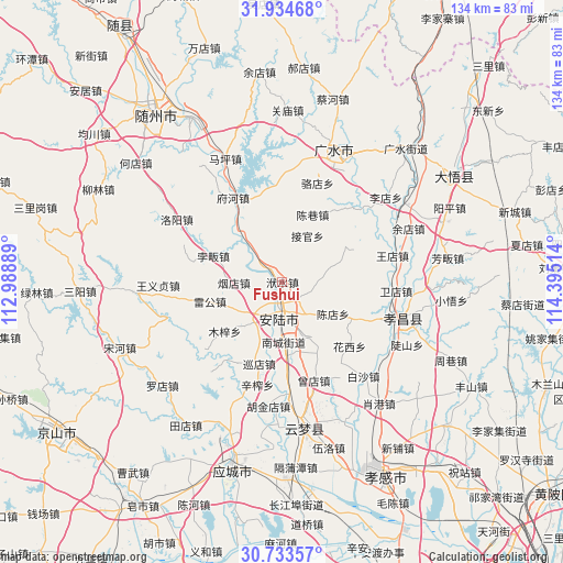
Fushui GPS coordinates[2]
31° 20' 9.744" North, 113° 41' 31.236" East
| Map corner | latitude | longitude |
|---|---|---|
| Upper-left | 31.93468°, | 112.98889° |
| Center: | 31.33604°, | 113.69201° |
| Lower-right: | 30.73357°, | 114.39514° |
| Map W x H: | 133.6×133.6 km | = 83×83mi |
| max Lat: | 53.31946° ⇑42.7% North |
| Fushui: | 31.33604° |
| min Lat: | ⇓57.3% South 18.22056° |
| min Long | Fushui | max Long |
| 75.07348° | 113.69201° | 134.28917° |
| W 46.9%⇐ | ⇒53.1% E |
Elevation
Elevation of Fushui is 44 m = 144 ft, and this is 440.8 m = 1446 ft below average elevation for this country.
| Max E: |
5622 m = 18445 ft | 72.3% |
| Avg. | 484.8 m = 1591 ft | |
| Fushui | 44 m = 144 ft | |
Min E: |
-3 m = -10 ft | 27.7% |
See also: China elevation on elevation.city.
Geographical zone
Fushui is located in North temperate zone (between Tropic of Cancer and the Arctic Circle). Distance of this Northern Tropic circle is 878.3 km =545.8 mi to South.| Distance of | km | miles | from Fushui |
|---|---|---|---|
| North Pole | 6522.8 | 4053.1 | to North |
| Arctic Circle | 3916.9 | 2433.8 | to North |
| Tropic Cancer | 878.3 | 545.8 | to South |
| Equator | 3484.2 | 2165 | to South |


Nearby cities:
15 places around Fushui: (largest is in red/bold)
• Anlu
8.8 km =5.5 mi,  188°
188°
• Beifan
16.9 km =10.5 mi,  288°
288°
• Chendian
14.1 km =8.8 mi,  122°
122°
• Chenxiang
17.5 km =10.9 mi,  24°
24°
• Daodian
17.1 km =10.6 mi,  169°
169°
• Jieguan
12.5 km =7.8 mi,  28°
28°
• Leigong
17.8 km =11.1 mi,  254°
254°
• Lidian
14.7 km =9.1 mi,  154°
154°
• Muzi
18.2 km =11.3 mi,  229°
229°
• Nancheng
14.2 km =8.8 mi,  178°
178°
• Pinglin
12.1 km =7.5 mi,  317°
317°
• Tangdi
14.7 km =9.1 mi,  222°
222°
• Xundian
20.1 km =12.5 mi,  195°
195°
• Yandian
11.9 km =7.4 mi,  269°
269°
• Zhaopeng
17.2 km =10.7 mi,  60°
60°
Sources, notices
• [Note1] Compared only with cities in China existing in our database
• [Src1] Map data: © OpenStreetMap contributors (CC-BY-SA)
• [Src2] Other city data from geonames.org with taken over terms of usage.
• [Src3] Geographical zone / Annual Mean Temperature by Robert A. Rohde @ Wikipedia
