Beifan geodata
Beifan (Hubei) is a seat of a fourth-order administrative division; located in China in Asia/Shanghai (GMT+8) time zone. In our database, there are 1268 cities with bigger population. Compared to other cities in China, 57.6% of cities are located further ↓South; 54.2% of cities are located further →East and 64.9% of cities have higher elevation than Beifan. Note1


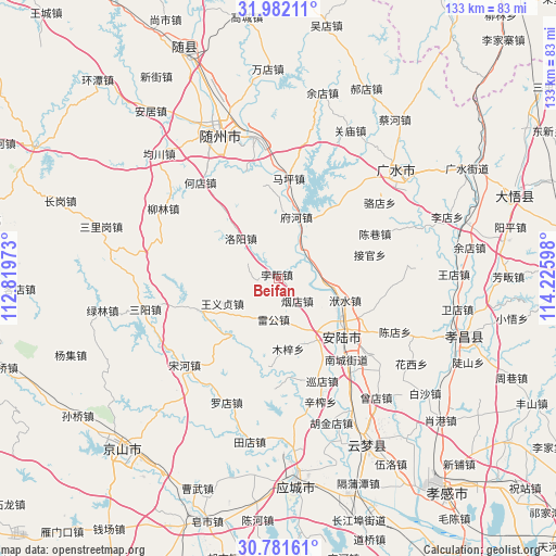
Beifan GPS coordinates[2]
31° 23' 1.608" North, 113° 31' 22.26" East
| Map corner | latitude | longitude |
|---|---|---|
| Upper-left | 31.98211°, | 112.81973° |
| Center: | 31.38378°, | 113.52285° |
| Lower-right: | 30.78161°, | 114.22598° |
| Map W x H: | 133.5×133.5 km | = 83×83mi |
| max Lat: | 53.31946° ⇑42.4% North |
| Beifan: | 31.38378° |
| min Lat: | ⇓57.6% South 18.22056° |
| min Long | Beifan | max Long |
| 75.07348° | 113.52285° | 134.28917° |
| W 45.8%⇐ | ⇒54.2% E |
Elevation
Elevation of Beifan is 73 m = 240 ft, and this is 411.8 m = 1351 ft below average elevation for this country.
| Max E: |
5622 m = 18445 ft | 64.9% |
| Avg. | 484.8 m = 1591 ft | |
| Beifan | 73 m = 240 ft | |
Min E: |
-3 m = -10 ft | 35.1% |
See also: China elevation on elevation.city.
Geographical zone
Beifan is located in North temperate zone (between Tropic of Cancer and the Arctic Circle). Distance of this Northern Tropic circle is 883.6 km =549 mi to South.| Distance of | km | miles | from Beifan |
|---|---|---|---|
| North Pole | 6517.5 | 4049.8 | to North |
| Arctic Circle | 3911.6 | 2430.6 | to North |
| Tropic Cancer | 883.6 | 549 | to South |
| Equator | 3489.5 | 2168.3 | to South |


Nearby cities:
15 places around Beifan: (largest is in red/bold)
• Anlu
20.4 km =12.7 mi,  133°
133°
• Changling
15.9 km =9.9 mi,  20°
20°
• Chenxiang
25.5 km =15.8 mi,  65°
65°
• Fuhe
14.6 km =9.1 mi, 16°
• Fushui
16.9 km =10.5 mi,  108°
108°
• Jieguan
22.7 km =14.1 mi,  75°
75°
• Leigong
10.1 km =6.3 mi,  186°
186°
• Luoyang
13.6 km =8.5 mi,  316°
316°
• Maping
24.3 km =15.1 mi,  6°
6°
• Muzi
17.3 km =10.7 mi,  172°
172°
• Pingba
21 km =13 mi,  248°
248°
• Pinglin
8.6 km =5.3 mi, 65°
• Tangdi
17.2 km =10.7 mi,  159°
159°
• Wangyi Zhendian
14.8 km =9.2 mi, 246°
• Yandian
6.8 km =4.2 mi,  142°
142°
Sources, notices
• [Note1] Compared only with cities in China existing in our database
• [Src1] Map data: © OpenStreetMap contributors (CC-BY-SA)
• [Src2] Other city data from geonames.org with taken over terms of usage.
• [Src3] Geographical zone / Annual Mean Temperature by Robert A. Rohde @ Wikipedia
