Guzhu geodata
Guzhu (Fujian) is a seat of a fourth-order administrative division; located in China in Asia/Shanghai (GMT+8) time zone. In our database, there are 1268 cities with bigger population. Compared to other cities in China, 87.6% of cities are located further ↑North; 65.9% of cities are located further ←West and 72.3% of cities have lower elevation than Guzhu. Note1


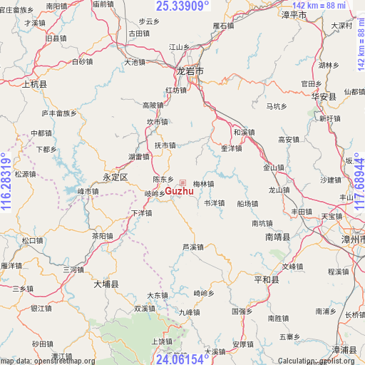
Guzhu GPS coordinates[2]
24° 42' 7.02" North, 116° 59' 10.716" East
| Map corner | latitude | longitude |
|---|---|---|
| Upper-left | 25.33909°, | 116.28319° |
| Center: | 24.70195°, | 116.98631° |
| Lower-right: | 24.06154°, | 117.68944° |
| Map W x H: | 142.1×142.1 km | = 88.3×88.3mi |
| max Lat: | 53.31946° ⇑87.6% North |
| Guzhu: | 24.70195° |
| min Lat: | ⇓12.4% South 18.22056° |
| min Long | Guzhu | max Long |
| 75.07348° | 116.98631° | 134.28917° |
| W 65.9%⇐ | ⇒34.1% E |
Elevation
Elevation of Guzhu is 460 m = 1509 ft, and this is 24.8 m = 81 ft below average elevation for this country.
| Max E: |
5622 m = 18445 ft | 27.7% |
| Avg. | 484.8 m = 1591 ft | |
| Guzhu | 460 m = 1509 ft | |
Min E: |
-3 m = -10 ft | 72.3% |
See also: China elevation on elevation.city.
Geographical zone
Guzhu is located in North temperate zone (between Tropic of Cancer and the Arctic Circle). Distance of this Northern Tropic circle is 140.7 km =87.4 mi to South.| Distance of | km | miles | from Guzhu |
|---|---|---|---|
| North Pole | 7260.5 | 4511.5 | to North |
| Arctic Circle | 4654.6 | 2892.2 | to North |
| Tropic Cancer | 140.7 | 87.4 | to South |
| Equator | 2746.6 | 1706.7 | to South |


Nearby cities:
15 places around Guzhu: (largest is in red/bold)
• Chendong
7.9 km =4.9 mi,  284°
284°
• Chengjiao
27.1 km =16.8 mi, 275°
• Daxi
11.1 km =6.9 mi,  224°
224°
• Fengcheng
26.6 km =16.5 mi, 275°
• Fushi
16.5 km =10.3 mi,  335°
335°
• Hukeng
7.2 km =4.5 mi,  214°
214°
• Hulei
20.2 km =12.6 mi,  300°
300°
• Hushan
28.2 km =17.5 mi,  203°
203°
• Jinsha
30.9 km =19.2 mi, 279°
• Kanshi
26 km =16.2 mi, 337°
• Peifeng
23.3 km =14.5 mi,  348°
348°
• Qiling
10.4 km =6.5 mi,  253°
253°
• Tangbao
26 km =16.2 mi,  317°
317°
• Xiayang
19.1 km =11.9 mi,  234°
234°
• Xixi
27.1 km =16.8 mi,  288°
288°
Sources, notices
• [Note1] Compared only with cities in China existing in our database
• [Src1] Map data: © OpenStreetMap contributors (CC-BY-SA)
• [Src2] Other city data from geonames.org with taken over terms of usage.
• [Src3] Geographical zone / Annual Mean Temperature by Robert A. Rohde @ Wikipedia
