Dahe geodata
Dahe (Fujian) is a seat of a fourth-order administrative division; located in China in Asia/Shanghai (GMT+8) time zone. In our database, there are 1268 cities with bigger population. Compared to other cities in China, 84.7% of cities are located further ↑North; 60.6% of cities are located further ←West and 65.1% of cities have lower elevation than Dahe. Note1


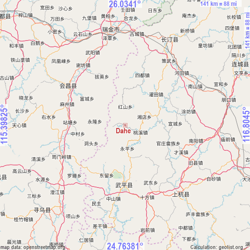
Dahe GPS coordinates[2]
25° 24' 2.268" North, 116° 6' 4.932" East
| Map corner | latitude | longitude |
|---|---|---|
| Upper-left | 26.0341°, | 115.39825° |
| Center: | 25.40063°, | 116.10137° |
| Lower-right: | 24.76381°, | 116.8045° |
| Map W x H: | 141.2×141.2 km | = 87.7×87.7mi |
| max Lat: | 53.31946° ⇑84.7% North |
| Dahe: | 25.40063° |
| min Lat: | ⇓15.3% South 18.22056° |
| min Long | Dahe | max Long |
| 75.07348° | 116.10137° | 134.28917° |
| W 60.6%⇐ | ⇒39.4% E |
Elevation
Elevation of Dahe is 327 m = 1073 ft, and this is 157.8 m = 518 ft below average elevation for this country.
| Max E: |
5622 m = 18445 ft | 34.9% |
| Avg. | 484.8 m = 1591 ft | |
| Dahe | 327 m = 1073 ft | |
Min E: |
-3 m = -10 ft | 65.1% |
See also: China elevation on elevation.city.
Geographical zone
Dahe is located in North temperate zone (between Tropic of Cancer and the Arctic Circle). Distance of this Northern Tropic circle is 218.4 km =135.7 mi to South.| Distance of | km | miles | from Dahe |
|---|---|---|---|
| North Pole | 7182.8 | 4463.2 | to North |
| Arctic Circle | 4576.9 | 2844 | to North |
| Tropic Cancer | 218.4 | 135.7 | to South |
| Equator | 2824.3 | 1754.9 | to South |


Nearby cities:
15 places around Dahe: (largest is in red/bold)
• Dongtou
21.8 km =13.5 mi,  241°
241°
• Fucheng
26.3 km =16.3 mi,  305°
305°
• Guanzhuang
26.5 km =16.5 mi,  112°
112°
• Hongshan
10.5 km =6.5 mi,  0°
0°
• Shanhu
29.5 km =18.3 mi,  129°
129°
• Taoxi
9.5 km =5.9 mi,  115°
115°
• Wan’an
29.6 km =18.4 mi,  181°
181°
• Xiangdian
11.9 km =7.4 mi,  66°
66°
• Xuancheng
28.4 km =17.6 mi,  88°
88°
• Yanggu
21.6 km =13.4 mi, 94°
• Yonglong
17.2 km =10.7 mi,  276°
276°
• Yongping
13.2 km =8.2 mi,  174°
174°
• Zhongbao
28.1 km =17.5 mi,  144°
144°
• Zhongcun
27.2 km =16.9 mi,  259°
259°
• Zhuotian
24.8 km =15.4 mi,  44°
44°
Sources, notices
• [Note1] Compared only with cities in China existing in our database
• [Src1] Map data: © OpenStreetMap contributors (CC-BY-SA)
• [Src2] Other city data from geonames.org with taken over terms of usage.
• [Src3] Geographical zone / Annual Mean Temperature by Robert A. Rohde @ Wikipedia
