Fubao geodata
Fubao (Sichuan) is a populated place; located in China in Asia/Shanghai (GMT+8) time zone. With population of 3,500 people, there are 924 cities with bigger population in this country. Compared to other cities in China, 67.3% of cities are located further ↑North; 86.6% of cities are located further →East and 58.9% of cities have lower elevation than Fubao. Note1


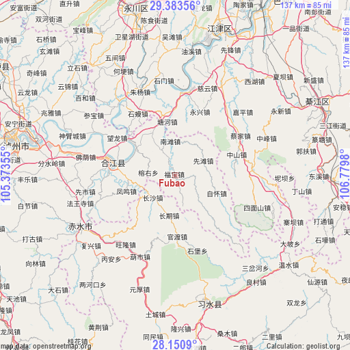
Fubao GPS coordinates[2]
28° 46' 8.58" North, 106° 4' 36.012" East
| Map corner | latitude | longitude |
|---|---|---|
| Upper-left | 29.38356°, | 105.37355° |
| Center: | 28.76905°, | 106.07667° |
| Lower-right: | 28.1509°, | 106.7798° |
| Map W x H: | 137.1×137.1 km | = 85.2×85.2mi |
| max Lat: | 53.31946° ⇑67.3% North |
| Fubao: | 28.76905° |
| min Lat: | ⇓32.7% South 18.22056° |
| min Long | Fubao | max Long |
| 75.07348° | 106.07667° | 134.28917° |
| W 13.4%⇐ | ⇒86.6% E |
Elevation
Elevation of Fubao is 246 m = 807 ft, and this is 238.8 m = 783 ft below average elevation for this country.
| Max E: |
5622 m = 18445 ft | 41.1% |
| Avg. | 484.8 m = 1591 ft | |
| Fubao | 246 m = 807 ft | |
Min E: |
-3 m = -10 ft | 58.9% |
See also: China elevation on elevation.city.
Geographical zone
Fubao is located in North temperate zone (between Tropic of Cancer and the Arctic Circle). Distance of this Northern Tropic circle is 592.9 km =368.4 mi to South.| Distance of | km | miles | from Fubao |
|---|---|---|---|
| North Pole | 6808.2 | 4230.4 | to North |
| Arctic Circle | 4202.4 | 2611.2 | to North |
| Tropic Cancer | 592.9 | 368.4 | to South |
| Equator | 3198.8 | 1987.6 | to South |


Nearby cities:
15 places around Fubao: (largest is in red/bold)
• Bailin
37.6 km =23.4 mi,  95°
95°
• Baisha
32.9 km =20.4 mi,  7°
7°
• Caijia
30 km =18.6 mi,  58°
58°
• Changqi
16.6 km =10.3 mi,  182°
182°
• Changsha
12.4 km =7.7 mi,  223°
223°
• Ciyun
36.3 km =22.6 mi,  20°
20°
• Guandu
22.5 km =14 mi,  173°
173°
• Hejiang
24.2 km =15 mi,  281°
281°
• Shima
28.5 km =17.7 mi,  328°
328°
• Shimen
37.1 km =23.1 mi,  353°
353°
• Songgai
36.8 km =22.9 mi, 330°
• Xiantan
12.6 km =7.8 mi, 64°
• Yongxing
26.4 km =16.4 mi, 21°
• Zhutuo
35.5 km =22.1 mi,  321°
321°
• Zhuyang
35.2 km =21.9 mi,  338°
338°
Sources, notices
• [Note1] Compared only with cities in China existing in our database
• [Src1] Map data: © OpenStreetMap contributors (CC-BY-SA)
• [Src2] Other city data from geonames.org with taken over terms of usage.
• [Src3] Geographical zone / Annual Mean Temperature by Robert A. Rohde @ Wikipedia
