Caijia geodata
Caijia (Chongqing) is a seat of a fourth-order administrative division; located in China in Asia/Shanghai (GMT+8) time zone. With population of 2,000 people, there are 1030 cities with bigger population in this country. Compared to other cities in China, 66.3% of cities are located further ↑North; 85.7% of cities are located further →East and 65.2% of cities have lower elevation than Caijia. Note1


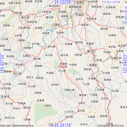
Caijia GPS coordinates[2]
28° 54' 32.004" North, 106° 20' 25.44" East
| Map corner | latitude | longitude |
|---|---|---|
| Upper-left | 29.52256°, | 105.63728° |
| Center: | 28.90889°, | 106.3404° |
| Lower-right: | 28.29156°, | 107.04353° |
| Map W x H: | 136.9×136.9 km | = 85.1×85.1mi |
| max Lat: | 53.31946° ⇑66.3% North |
| Caijia: | 28.90889° |
| min Lat: | ⇓33.7% South 18.22056° |
| min Long | Caijia | max Long |
| 75.07348° | 106.3404° | 134.28917° |
| W 14.3%⇐ | ⇒85.7% E |
Elevation
Elevation of Caijia is 330 m = 1083 ft, and this is 154.8 m = 508 ft below average elevation for this country.
| Max E: |
5622 m = 18445 ft | 34.8% |
| Avg. | 484.8 m = 1591 ft | |
| Caijia | 330 m = 1083 ft | |
Min E: |
-3 m = -10 ft | 65.2% |
See also: China elevation on elevation.city.
Geographical zone
Caijia is located in North temperate zone (between Tropic of Cancer and the Arctic Circle). Distance of this Northern Tropic circle is 608.4 km =378 mi to South.| Distance of | km | miles | from Caijia |
|---|---|---|---|
| North Pole | 6792.7 | 4220.8 | to North |
| Arctic Circle | 4186.8 | 2601.6 | to North |
| Tropic Cancer | 608.4 | 378 | to South |
| Equator | 3214.4 | 1997.3 | to South |


Nearby cities:
15 places around Caijia: (largest is in red/bold)
• Bailin
22.5 km =14 mi,  148°
148°
• Baisha
27.5 km =17.1 mi,  308°
308°
• Ciyun
22.7 km =14.1 mi,  324°
324°
• Dongxi
35.3 km =21.9 mi,  117°
117°
• Dushi
32.7 km =20.3 mi,  34°
34°
• Fubao
30 km =18.6 mi,  238°
238°
• Gunan
32.5 km =20.2 mi,  67°
67°
• Guofuchang
26.2 km =16.3 mi,  104°
104°
• Jiasi
25.2 km =15.7 mi,  24°
24°
• Lishi
20.4 km =12.7 mi,  338°
338°
• Xiaba
28.4 km =17.6 mi,  35°
35°
• Xianfeng
33.7 km =20.9 mi,  353°
353°
• Xiantan
17.5 km =10.9 mi, 235°
• Yongxin
19.8 km =12.3 mi, 71°
• Yongxing
18.3 km =11.4 mi,  299°
299°
Sources, notices
• [Note1] Compared only with cities in China existing in our database
• [Src1] Map data: © OpenStreetMap contributors (CC-BY-SA)
• [Src2] Other city data from geonames.org with taken over terms of usage.
• [Src3] Geographical zone / Annual Mean Temperature by Robert A. Rohde @ Wikipedia
