Changqi geodata
Changqi (Guizhou) is a seat of a fourth-order administrative division; located in China in Asia/Shanghai (GMT+8) time zone. In our database, there are 1268 cities with bigger population. Compared to other cities in China, 68.7% of cities are located further ↑North; 86.6% of cities are located further →East and 70.5% of cities have lower elevation than Changqi. Note1


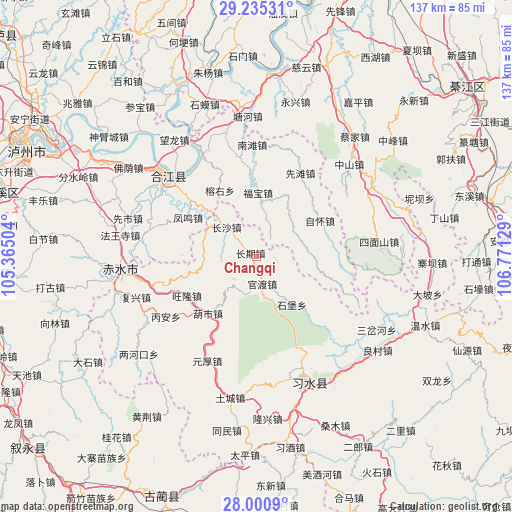
Changqi GPS coordinates[2]
28° 37' 11.712" North, 106° 4' 5.376" East
| Map corner | latitude | longitude |
|---|---|---|
| Upper-left | 29.23531°, | 105.36504° |
| Center: | 28.61992°, | 106.06816° |
| Lower-right: | 28.0009°, | 106.77129° |
| Map W x H: | 137.3×137.3 km | = 85.3×85.3mi |
| max Lat: | 53.31946° ⇑68.7% North |
| Changqi: | 28.61992° |
| min Lat: | ⇓31.3% South 18.22056° |
| min Long | Changqi | max Long |
| 75.07348° | 106.06816° | 134.28917° |
| W 13.4%⇐ | ⇒86.6% E |
Elevation
Elevation of Changqi is 421 m = 1381 ft, and this is 63.8 m = 209 ft below average elevation for this country.
| Max E: |
5622 m = 18445 ft | 29.5% |
| Avg. | 484.8 m = 1591 ft | |
| Changqi | 421 m = 1381 ft | |
Min E: |
-3 m = -10 ft | 70.5% |
See also: China elevation on elevation.city.
Geographical zone
Changqi is located in North temperate zone (between Tropic of Cancer and the Arctic Circle). Distance of this Northern Tropic circle is 576.3 km =358.1 mi to South.| Distance of | km | miles | from Changqi |
|---|---|---|---|
| North Pole | 6824.8 | 4240.7 | to North |
| Arctic Circle | 4218.9 | 2621.5 | to North |
| Tropic Cancer | 576.3 | 358.1 | to South |
| Equator | 3182.2 | 1977.3 | to South |


Nearby cities:
15 places around Changqi: (largest is in red/bold)
• Bailin
40.4 km =25.1 mi,  71°
71°
• Caijia
41.7 km =25.9 mi,  39°
39°
• Changsha
10.7 km =6.6 mi,  314°
314°
• Datong
40.4 km =25.1 mi,  250°
250°
• Donghuang
35 km =21.7 mi,  155°
155°
• Fubao
16.6 km =10.3 mi,  2°
2°
• Guandu
6.6 km =4.1 mi,  149°
149°
• Hejiang
31.3 km =19.4 mi, 312°
• Liangcunchang
42.1 km =26.2 mi,  124°
124°
• Sanchahe
37.8 km =23.5 mi,  111°
111°
• Sanyuanchang
30.9 km =19.2 mi, 163°
• Tiantai
31.7 km =19.7 mi,  261°
261°
• Tucheng
37.1 km =23.1 mi,  191°
191°
• Xiantan
25.2 km =15.7 mi,  28°
28°
• Yuanhou
32.3 km =20.1 mi,  196°
196°
Sources, notices
• [Note1] Compared only with cities in China existing in our database
• [Src1] Map data: © OpenStreetMap contributors (CC-BY-SA)
• [Src2] Other city data from geonames.org with taken over terms of usage.
• [Src3] Geographical zone / Annual Mean Temperature by Robert A. Rohde @ Wikipedia
