Xiantai geodata
Xiantai (Henan) is a seat of a fourth-order administrative division; located in China in Asia/Shanghai (GMT+8) time zone. In our database, there are 1268 cities with bigger population. Compared to other cities in China, 68.1% of cities are located further ↓South; 54.6% of cities are located further →East and 61.7% of cities have higher elevation than Xiantai. Note1


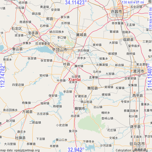
Xiantai GPS coordinates[2]
33° 31' 48.36" North, 113° 27' 3.384" East
| Map corner | latitude | longitude |
|---|---|---|
| Upper-left | 34.11423°, | 112.74782° |
| Center: | 33.5301°, | 113.45094° |
| Lower-right: | 32.942°, | 114.15407° |
| Map W x H: | 130.3×130.3 km | = 81×81mi |
| max Lat: | 53.31946° ⇑31.9% North |
| Xiantai: | 33.5301° |
| min Lat: | ⇓68.1% South 18.22056° |
| min Long | Xiantai | max Long |
| 75.07348° | 113.45094° | 134.28917° |
| W 45.4%⇐ | ⇒54.6% E |
Elevation
Elevation of Xiantai is 89 m = 292 ft, and this is 395.8 m = 1299 ft below average elevation for this country.
| Max E: |
5622 m = 18445 ft | 61.7% |
| Avg. | 484.8 m = 1591 ft | |
| Xiantai | 89 m = 292 ft | |
Min E: |
-3 m = -10 ft | 38.3% |
See also: China elevation on elevation.city.
Geographical zone
Xiantai is located in North temperate zone (between Tropic of Cancer and the Arctic Circle). Distance of this Northern Tropic circle is 1122.3 km =697.4 mi to South.| Distance of | km | miles | from Xiantai |
|---|---|---|---|
| North Pole | 6278.9 | 3901.5 | to North |
| Arctic Circle | 3673 | 2282.3 | to North |
| Tropic Cancer | 1122.3 | 697.4 | to South |
| Equator | 3728.2 | 2316.6 | to South |


Nearby cities:
15 places around Xiantai: (largest is in red/bold)
• Baohe
10.5 km =6.5 mi,  140°
140°
• Dengli
16.5 km =10.3 mi,  16°
16°
• Gongdian
14.8 km =9.2 mi,  354°
354°
• Jiuxian
14.5 km =9 mi,  254°
254°
• Kuangshan
17.3 km =10.7 mi,  166°
166°
• Kunyang
14 km =8.7 mi,  315°
315°
• Liancun
9.3 km =5.8 mi,  13°
13°
• Longquan
5.2 km =3.2 mi,  207°
207°
• Mazhuang
12 km =7.5 mi,  304°
304°
• Mengzhai
14.7 km =9.1 mi,  84°
84°
• Shuizhai
13.3 km =8.3 mi,  39°
39°
• Tianzhuang
9.9 km =6.2 mi,  294°
294°
• Wenfeng
14.8 km =9.2 mi,  128°
128°
• Wuquan
14.7 km =9.1 mi, 130°
• Xindian
14.9 km =9.3 mi, 209°
Sources, notices
• [Note1] Compared only with cities in China existing in our database
• [Src1] Map data: © OpenStreetMap contributors (CC-BY-SA)
• [Src2] Other city data from geonames.org with taken over terms of usage.
• [Src3] Geographical zone / Annual Mean Temperature by Robert A. Rohde @ Wikipedia
