Jiuxian geodata
Jiuxian (Henan) is a seat of a fourth-order administrative division; located in China in Asia/Shanghai (GMT+8) time zone. In our database, there are 1268 cities with bigger population. Compared to other cities in China, 68.1% of cities are located further ↓South; 55.6% of cities are located further →East and 58.6% of cities have higher elevation than Jiuxian. Note1


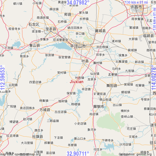
Jiuxian GPS coordinates[2]
33° 29' 43.62" North, 113° 17' 58.74" East
| Map corner | latitude | longitude |
|---|---|---|
| Upper-left | 34.07982°, | 112.59653° |
| Center: | 33.49545°, | 113.29965° |
| Lower-right: | 32.90711°, | 114.00278° |
| Map W x H: | 130.4×130.4 km | = 81×81mi |
| max Lat: | 53.31946° ⇑31.9% North |
| Jiuxian: | 33.49545° |
| min Lat: | ⇓68.1% South 18.22056° |
| min Long | Jiuxian | max Long |
| 75.07348° | 113.29965° | 134.28917° |
| W 44.4%⇐ | ⇒55.6% E |
Elevation
Elevation of Jiuxian is 107 m = 351 ft, and this is 377.8 m = 1240 ft below average elevation for this country.
| Max E: |
5622 m = 18445 ft | 58.6% |
| Avg. | 484.8 m = 1591 ft | |
| Jiuxian | 107 m = 351 ft | |
Min E: |
-3 m = -10 ft | 41.4% |
See also: China elevation on elevation.city.
Geographical zone
Jiuxian is located in North temperate zone (between Tropic of Cancer and the Arctic Circle). Distance of this Northern Tropic circle is 1118.4 km =694.9 mi to South.| Distance of | km | miles | from Jiuxian |
|---|---|---|---|
| North Pole | 6282.7 | 3903.9 | to North |
| Arctic Circle | 3676.8 | 2284.7 | to North |
| Tropic Cancer | 1118.4 | 694.9 | to South |
| Equator | 3724.3 | 2314.2 | to South |


Nearby cities:
15 places around Jiuxian: (largest is in red/bold)
• Baohe
21.2 km =13.2 mi,  101°
101°
• Bao’an
13.9 km =8.6 mi,  205°
205°
• Changcun
17 km =10.6 mi,  284°
284°
• Kuangshan
22.3 km =13.9 mi,  125°
125°
• Kunyang
14.5 km =9 mi,  16°
16°
• Liancun
20.7 km =12.9 mi,  51°
51°
• Longquan
11.7 km =7.3 mi,  93°
93°
• Mazhuang
11.3 km =7 mi, 21°
• Miaojie
21.6 km =13.4 mi,  135°
135°
• Rendian
16.1 km =10 mi,  335°
335°
• Tianzhuang
9.4 km =5.8 mi,  32°
32°
• Xiali
9 km =5.6 mi,  295°
295°
• Xiantai
14.5 km =9 mi,  74°
74°
• Xindian
11.3 km =7 mi, 143°
• Zhangguanying
21.1 km =13.1 mi,  326°
326°
Sources, notices
• [Note1] Compared only with cities in China existing in our database
• [Src1] Map data: © OpenStreetMap contributors (CC-BY-SA)
• [Src2] Other city data from geonames.org with taken over terms of usage.
• [Src3] Geographical zone / Annual Mean Temperature by Robert A. Rohde @ Wikipedia
