Fengshan geodata
Fengshan (Hubei) is a seat of a fourth-order administrative division; located in China in Asia/Shanghai (GMT+8) time zone. In our database, there are 1268 cities with bigger population. Compared to other cities in China, 55.6% of cities are located further ↓South; 50.3% of cities are located further →East and 64.1% of cities have higher elevation than Fengshan. Note1


Fengshan GPS coordinates[2]
31° 6' 43.848" North, 114° 9' 47.124" East
| Map corner | latitude | longitude |
|---|---|---|
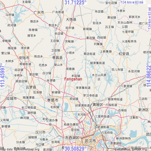
| Upper-left | 31.71225°, | 113.45997° |
| Center: | 31.11218°, | 114.16309° |
| Lower-right: | 30.50829°, | 114.86622° |
| Map W x H: | 133.9×133.9 km | = 83.2×83.2mi |
| max Lat: | 53.31946° ⇑44.4% North |
| Fengshan: | 31.11218° |
| min Lat: | ⇓55.6% South 18.22056° |
| min Long | Fengshan | max Long |
| 75.07348° | 114.16309° | 134.28917° |
| W 49.7%⇐ | ⇒50.3% E |
Elevation
Elevation of Fengshan is 77 m = 253 ft, and this is 407.8 m = 1338 ft below average elevation for this country.
| Max E: |
5622 m = 18445 ft | 64.1% |
| Avg. | 484.8 m = 1591 ft | |
| Fengshan | 77 m = 253 ft | |
Min E: |
-3 m = -10 ft | 35.9% |
See also: China elevation on elevation.city.
Geographical zone
Fengshan is located in North temperate zone (between Tropic of Cancer and the Arctic Circle). Distance of this Northern Tropic circle is 853.4 km =530.3 mi to South.| Distance of | km | miles | from Fengshan |
|---|---|---|---|
| North Pole | 6547.7 | 4068.6 | to North |
| Arctic Circle | 3941.8 | 2449.3 | to North |
| Tropic Cancer | 853.4 | 530.3 | to South |
| Equator | 3459.4 | 2149.6 | to South |


Nearby cities:
15 places around Fengshan: (largest is in red/bold)
• Baisha
25.7 km =16 mi,  275°
275°
• Caidian
23.5 km =14.6 mi,  31°
31°
• Changxuanling
17.4 km =10.8 mi,  95°
95°
• Doushan
18.2 km =11.3 mi,  303°
303°
• Lijiaji
12.2 km =7.6 mi,  146°
146°
• Sancha
21.1 km =13.1 mi,  208°
208°
• Xiaogang
22.2 km =13.8 mi,  259°
259°
• Xiaowu
21.1 km =13.1 mi,  347°
347°
• Xihe
18.6 km =11.6 mi,  231°
231°
• Xinpu
22.6 km =14 mi, 230°
• Yangdian
10.9 km =6.8 mi, 209°
• Yaojiaji
22.4 km =13.9 mi,  59°
59°
• Zhouxiang
7.9 km =4.9 mi,  322°
322°
• Zhuzhan
20.6 km =12.8 mi,  182°
182°
• Zougang
13.1 km =8.1 mi, 256°
Sources, notices
• [Note1] Compared only with cities in China existing in our database
• [Src1] Map data: © OpenStreetMap contributors (CC-BY-SA)
• [Src2] Other city data from geonames.org with taken over terms of usage.
• [Src3] Geographical zone / Annual Mean Temperature by Robert A. Rohde @ Wikipedia
