Fukou geodata
Fukou (Fujian) is a seat of a fourth-order administrative division; located in China in Asia/Shanghai (GMT+8) time zone. In our database, there are 1268 cities with bigger population. Compared to other cities in China, 83.3% of cities are located further ↑North; 73% of cities are located further ←West and 55.2% of cities have lower elevation than Fukou. Note1


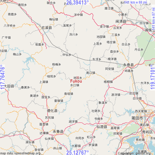
Fukou GPS coordinates[2]
25° 45' 45.324" North, 118° 28' 4.368" East
| Map corner | latitude | longitude |
|---|---|---|
| Upper-left | 26.39413°, | 117.76476° |
| Center: | 25.76259°, | 118.46788° |
| Lower-right: | 25.12767°, | 119.17101° |
| Map W x H: | 140.8×140.8 km | = 87.5×87.5mi |
| max Lat: | 53.31946° ⇑83.3% North |
| Fukou: | 25.76259° |
| min Lat: | ⇓16.7% South 18.22056° |
| min Long | Fukou | max Long |
| 75.07348° | 118.46788° | 134.28917° |
| W 73%⇐ | ⇒27% E |
Elevation
Elevation of Fukou is 208 m = 682 ft, and this is 276.8 m = 908 ft below average elevation for this country.
| Max E: |
5622 m = 18445 ft | 44.8% |
| Avg. | 484.8 m = 1591 ft | |
| Fukou | 208 m = 682 ft | |
Min E: |
-3 m = -10 ft | 55.2% |
See also: China elevation on elevation.city.
Geographical zone
Fukou is located in North temperate zone (between Tropic of Cancer and the Arctic Circle). Distance of this Northern Tropic circle is 258.6 km =160.7 mi to South.| Distance of | km | miles | from Fukou |
|---|---|---|---|
| North Pole | 7142.5 | 4438.1 | to North |
| Arctic Circle | 4536.6 | 2818.9 | to North |
| Tropic Cancer | 258.6 | 160.7 | to South |
| Equator | 2864.5 | 1779.9 | to South |


Nearby cities:
15 places around Fukou: (largest is in red/bold)
• Changqing
17.6 km =10.9 mi,  39°
39°
• Dongyang
24.1 km =15 mi,  45°
45°
• Fengshan
22.6 km =14 mi,  156°
156°
• Gaiyang
8.9 km =5.5 mi,  10°
10°
• Gekeng
28.3 km =17.6 mi,  289°
289°
• Guiyang
24 km =14.9 mi,  272°
272°
• Leifeng
27.1 km =16.8 mi,  220°
220°
• Nancheng
16.3 km =10.1 mi,  210°
210°
• Shuikou
6.8 km =4.2 mi, 213°
• Songkou
12.6 km =7.8 mi,  68°
68°
• Tong’an
29.9 km =18.6 mi, 74°
• Wutong
27.8 km =17.3 mi,  97°
97°
• Xiaba
28.8 km =17.9 mi, 50°
• Xiyuan
31.2 km =19.4 mi, 161°
• Zhongxian
23.1 km =14.4 mi,  334°
334°
Sources, notices
• [Note1] Compared only with cities in China existing in our database
• [Src1] Map data: © OpenStreetMap contributors (CC-BY-SA)
• [Src2] Other city data from geonames.org with taken over terms of usage.
• [Src3] Geographical zone / Annual Mean Temperature by Robert A. Rohde @ Wikipedia
