Fengcheng geodata
Fengcheng (Guangdong) is a seat of a fourth-order administrative division; located in China in Asia/Shanghai (GMT+8) time zone. In our database, there are 1268 cities with bigger population. Compared to other cities in China, 90.2% of cities are located further ↑North; 50.1% of cities are located further →East and 50.5% of cities have higher elevation than Fengcheng. Note1


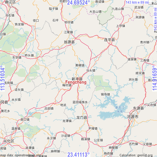
Fengcheng GPS coordinates[2]
24° 3' 17.244" North, 114° 12' 48.456" East
| Map corner | latitude | longitude |
|---|---|---|
| Upper-left | 24.69524°, | 113.51034° |
| Center: | 24.05479°, | 114.21346° |
| Lower-right: | 23.41113°, | 114.91659° |
| Map W x H: | 142.8×142.8 km | = 88.7×88.7mi |
| max Lat: | 53.31946° ⇑90.2% North |
| Fengcheng: | 24.05479° |
| min Lat: | ⇓9.8% South 18.22056° |
| min Long | Fengcheng | max Long |
| 75.07348° | 114.21346° | 134.28917° |
| W 49.9%⇐ | ⇒50.1% E |
Elevation
Elevation of Fengcheng is 160 m = 525 ft, and this is 324.8 m = 1066 ft below average elevation for this country.
| Max E: |
5622 m = 18445 ft | 50.5% |
| Avg. | 484.8 m = 1591 ft | |
| Fengcheng | 160 m = 525 ft | |
Min E: |
-3 m = -10 ft | 49.5% |
See also: China elevation on elevation.city.
Geographical zone
Fengcheng is located in North temperate zone (between Tropic of Cancer and the Arctic Circle). Distance of this Northern Tropic circle is 68.7 km =42.7 mi to South.| Distance of | km | miles | from Fengcheng |
|---|---|---|---|
| North Pole | 7332.4 | 4556.1 | to North |
| Arctic Circle | 4726.5 | 2936.9 | to North |
| Tropic Cancer | 68.7 | 42.7 | to South |
| Equator | 2674.6 | 1661.9 | to South |


Nearby cities:
15 places around Fengcheng: (largest is in red/bold)
• Dipa
26.7 km =16.6 mi,  210°
210°
• Huangca
13.1 km =8.1 mi,  4°
4°
• Huangqi
12.7 km =7.9 mi, 3°
• Huilong
31 km =19.3 mi,  290°
290°
• Lantian
21.4 km =13.3 mi,  176°
176°
• Longjie
20.8 km =12.9 mi,  45°
45°
• Matou
13.4 km =8.3 mi, 54°
• Meikeng
11.5 km =7.1 mi,  244°
244°
• Qixia
23.5 km =14.6 mi,  309°
309°
• Shatian
29.7 km =18.5 mi,  254°
254°
• Shijiao
15.2 km =9.4 mi,  111°
111°
• Tianyuan
25.5 km =15.8 mi, 54°
• Xiaozhen
20.5 km =12.7 mi, 247°
• Xichang
28.1 km =17.5 mi,  120°
120°
• Zhoupi
29.4 km =18.3 mi,  318°
318°
Sources, notices
• [Note1] Compared only with cities in China existing in our database
• [Src1] Map data: © OpenStreetMap contributors (CC-BY-SA)
• [Src2] Other city data from geonames.org with taken over terms of usage.
• [Src3] Geographical zone / Annual Mean Temperature by Robert A. Rohde @ Wikipedia
