Zhoupi geodata
Zhoupi (Guangdong) is a seat of a fourth-order administrative division; located in China in Asia/Shanghai (GMT+8) time zone. In our database, there are 1268 cities with bigger population. Compared to other cities in China, 89.4% of cities are located further ↑North; 51.2% of cities are located further →East and 55.9% of cities have higher elevation than Zhoupi. Note1


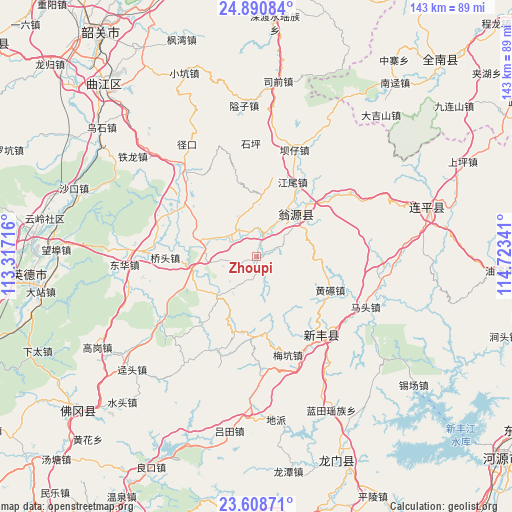
Zhoupi GPS coordinates[2]
24° 15' 5.004" North, 114° 1' 13.008" East
| Map corner | latitude | longitude |
|---|---|---|
| Upper-left | 24.89084°, | 113.31716° |
| Center: | 24.25139°, | 114.02028° |
| Lower-right: | 23.60871°, | 114.72341° |
| Map W x H: | 142.6×142.6 km | = 88.6×88.6mi |
| max Lat: | 53.31946° ⇑89.4% North |
| Zhoupi: | 24.25139° |
| min Lat: | ⇓10.6% South 18.22056° |
| min Long | Zhoupi | max Long |
| 75.07348° | 114.02028° | 134.28917° |
| W 48.8%⇐ | ⇒51.2% E |
Elevation
Elevation of Zhoupi is 125 m = 410 ft, and this is 359.8 m = 1180 ft below average elevation for this country.
| Max E: |
5622 m = 18445 ft | 55.9% |
| Avg. | 484.8 m = 1591 ft | |
| Zhoupi | 125 m = 410 ft | |
Min E: |
-3 m = -10 ft | 44.1% |
See also: China elevation on elevation.city.
Geographical zone
Zhoupi is located in North temperate zone (between Tropic of Cancer and the Arctic Circle). Distance of this Northern Tropic circle is 90.6 km =56.3 mi to South.| Distance of | km | miles | from Zhoupi |
|---|---|---|---|
| North Pole | 7310.6 | 4542.6 | to North |
| Arctic Circle | 4704.7 | 2923.4 | to North |
| Tropic Cancer | 90.6 | 56.3 | to South |
| Equator | 2696.5 | 1675.5 | to South |


Nearby cities:
15 places around Zhoupi: (largest is in red/bold)
• Guandu
14.3 km =8.9 mi,  284°
284°
• Hengshishui
25.1 km =15.6 mi,  297°
297°
• Hongling
25.3 km =15.7 mi,  345°
345°
• Huangca
22.4 km =13.9 mi,  113°
113°
• Huangqi
22.4 km =13.9 mi, 114°
• Huilong
14.6 km =9.1 mi,  220°
220°
• Jiangwei
22.7 km =14.1 mi,  28°
28°
• Liuli
8.7 km =5.4 mi,  320°
320°
• Longxian
15.7 km =9.8 mi,  48°
48°
• Meikeng
28.4 km =17.6 mi,  160°
160°
• Miaodun
11.1 km =6.9 mi,  266°
266°
• Qiaotou
25.3 km =15.7 mi, 270°
• Qingtang
18.2 km =11.3 mi,  257°
257°
• Qixia
7.1 km =4.4 mi,  168°
168°
• Wengcheng
24 km =14.9 mi,  305°
305°
Sources, notices
• [Note1] Compared only with cities in China existing in our database
• [Src1] Map data: © OpenStreetMap contributors (CC-BY-SA)
• [Src2] Other city data from geonames.org with taken over terms of usage.
• [Src3] Geographical zone / Annual Mean Temperature by Robert A. Rohde @ Wikipedia
