Huilong geodata
Huilong (Guangdong) is a seat of a fourth-order administrative division; located in China in Asia/Shanghai (GMT+8) time zone. In our database, there are 1268 cities with bigger population. Compared to other cities in China, 89.9% of cities are located further ↑North; 51.8% of cities are located further →East and 51.4% of cities have lower elevation than Huilong. Note1


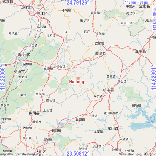
Huilong GPS coordinates[2]
24° 9' 4.68" North, 113° 55' 36.408" East
| Map corner | latitude | longitude |
|---|---|---|
| Upper-left | 24.79126°, | 113.22366° |
| Center: | 24.1513°, | 113.92678° |
| Lower-right: | 23.50812°, | 114.62991° |
| Map W x H: | 142.7×142.7 km | = 88.7×88.7mi |
| max Lat: | 53.31946° ⇑89.9% North |
| Huilong: | 24.1513° |
| min Lat: | ⇓10.1% South 18.22056° |
| min Long | Huilong | max Long |
| 75.07348° | 113.92678° | 134.28917° |
| W 48.2%⇐ | ⇒51.8% E |
Elevation
Elevation of Huilong is 176 m = 577 ft, and this is 308.8 m = 1013 ft below average elevation for this country.
| Max E: |
5622 m = 18445 ft | 48.6% |
| Avg. | 484.8 m = 1591 ft | |
| Huilong | 176 m = 577 ft | |
Min E: |
-3 m = -10 ft | 51.4% |
See also: China elevation on elevation.city.
Geographical zone
Huilong is located in North temperate zone (between Tropic of Cancer and the Arctic Circle). Distance of this Northern Tropic circle is 79.5 km =49.4 mi to South.| Distance of | km | miles | from Huilong |
|---|---|---|---|
| North Pole | 7321.7 | 4549.5 | to North |
| Arctic Circle | 4715.8 | 2930.3 | to North |
| Tropic Cancer | 79.5 | 49.4 | to South |
| Equator | 2685.4 | 1668.6 | to South |


Nearby cities:
15 places around Huilong: (largest is in red/bold)
• Baisha
18.6 km =11.6 mi,  248°
248°
• Guandu
15.3 km =9.5 mi,  343°
343°
• Hengshishui
26.1 km =16.2 mi,  330°
330°
• Liuli
18.2 km =11.3 mi,  12°
12°
• Meikeng
24.5 km =15.2 mi,  129°
129°
• Miaodun
10.6 km =6.6 mi,  351°
351°
• Qiaotou
19.5 km =12.1 mi,  305°
305°
• Qingtang
10.9 km =6.8 mi, 310°
• Qixia
11.7 km =7.3 mi,  68°
68°
• Shatian
18.6 km =11.6 mi,  178°
178°
• Xianggui
18.7 km =11.6 mi,  244°
244°
• Xiaozhen
21 km =13 mi,  151°
151°
• Yaotian
21.3 km =13.2 mi,  208°
208°
• Yuwan
26.6 km =16.5 mi,  273°
273°
• Zhoupi
14.6 km =9.1 mi,  40°
40°
Sources, notices
• [Note1] Compared only with cities in China existing in our database
• [Src1] Map data: © OpenStreetMap contributors (CC-BY-SA)
• [Src2] Other city data from geonames.org with taken over terms of usage.
• [Src3] Geographical zone / Annual Mean Temperature by Robert A. Rohde @ Wikipedia
