Meikeng geodata
Meikeng (Guangdong) is a seat of a fourth-order administrative division; located in China in Asia/Shanghai (GMT+8) time zone. In our database, there are 1268 cities with bigger population. Compared to other cities in China, 90.4% of cities are located further ↑North; 50.7% of cities are located further →East and 58.2% of cities have lower elevation than Meikeng. Note1


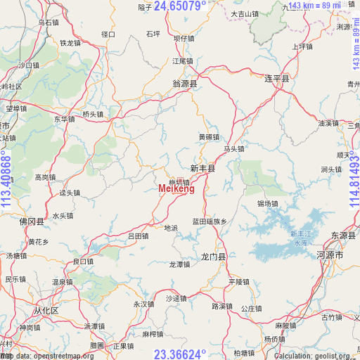
Meikeng GPS coordinates[2]
24° 0' 36.432" North, 114° 6' 42.48" East
| Map corner | latitude | longitude |
|---|---|---|
| Upper-left | 24.65079°, | 113.40868° |
| Center: | 24.01012°, | 114.1118° |
| Lower-right: | 23.36624°, | 114.81493° |
| Map W x H: | 142.8×142.8 km | = 88.7×88.7mi |
| max Lat: | 53.31946° ⇑90.4% North |
| Meikeng: | 24.01012° |
| min Lat: | ⇓9.6% South 18.22056° |
| min Long | Meikeng | max Long |
| 75.07348° | 114.1118° | 134.28917° |
| W 49.3%⇐ | ⇒50.7% E |
Elevation
Elevation of Meikeng is 238 m = 781 ft, and this is 246.8 m = 810 ft below average elevation for this country.
| Max E: |
5622 m = 18445 ft | 41.8% |
| Avg. | 484.8 m = 1591 ft | |
| Meikeng | 238 m = 781 ft | |
Min E: |
-3 m = -10 ft | 58.2% |
See also: China elevation on elevation.city.
Geographical zone
Meikeng is located in North temperate zone (between Tropic of Cancer and the Arctic Circle). Distance of this Northern Tropic circle is 63.8 km =39.6 mi to South.| Distance of | km | miles | from Meikeng |
|---|---|---|---|
| North Pole | 7337.4 | 4559.2 | to North |
| Arctic Circle | 4731.5 | 2940 | to North |
| Tropic Cancer | 63.8 | 39.6 | to South |
| Equator | 2669.7 | 1658.9 | to South |


Nearby cities:
15 places around Meikeng: (largest is in red/bold)
• Dipa
18.4 km =11.4 mi,  190°
190°
• Fengcheng
11.5 km =7.1 mi,  64°
64°
• Huangca
21.3 km =13.2 mi,  32°
32°
• Huangqi
20.8 km =12.9 mi, 32°
• Huilong
24.5 km =15.2 mi,  309°
309°
• Lantian
20.1 km =12.5 mi,  144°
144°
• Longjie
31.8 km =19.8 mi,  52°
52°
• Lütian
27.9 km =17.3 mi,  217°
217°
• Matou
24.7 km =15.3 mi, 58°
• Qixia
21.4 km =13.3 mi,  338°
338°
• Shatian
18.5 km =11.5 mi,  260°
260°
• Shijiao
24.5 km =15.2 mi,  91°
91°
• Xiaozhen
9.1 km =5.7 mi,  252°
252°
• Yaotian
29.2 km =18.1 mi, 264°
• Zhoupi
28.4 km =17.6 mi, 340°
Sources, notices
• [Note1] Compared only with cities in China existing in our database
• [Src1] Map data: © OpenStreetMap contributors (CC-BY-SA)
• [Src2] Other city data from geonames.org with taken over terms of usage.
• [Src3] Geographical zone / Annual Mean Temperature by Robert A. Rohde @ Wikipedia
