Shatian geodata
Shatian (Guangdong) is a seat of a fourth-order administrative division; located in China in Asia/Shanghai (GMT+8) time zone. In our database, there are 1268 cities with bigger population. Compared to other cities in China, 90.5% of cities are located further ↑North; 51.8% of cities are located further →East and 60% of cities have lower elevation than Shatian. Note1


Shatian GPS coordinates[2]
23° 59' 1.428" North, 113° 55' 54.48" East
| Map corner | latitude | longitude |
|---|---|---|
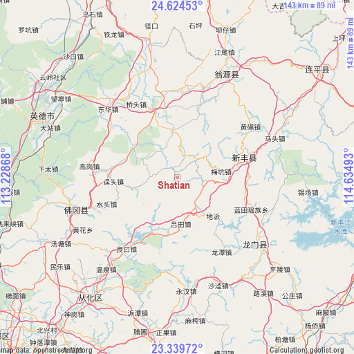
| Upper-left | 24.62453°, | 113.22868° |
| Center: | 23.98373°, | 113.9318° |
| Lower-right: | 23.33972°, | 114.63493° |
| Map W x H: | 142.9×142.9 km | = 88.8×88.8mi |
| max Lat: | 53.31946° ⇑90.5% North |
| Shatian: | 23.98373° |
| min Lat: | ⇓9.5% South 18.22056° |
| min Long | Shatian | max Long |
| 75.07348° | 113.9318° | 134.28917° |
| W 48.2%⇐ | ⇒51.8% E |
Elevation
Elevation of Shatian is 259 m = 850 ft, and this is 225.8 m = 741 ft below average elevation for this country.
| Max E: |
5622 m = 18445 ft | 40% |
| Avg. | 484.8 m = 1591 ft | |
| Shatian | 259 m = 850 ft | |
Min E: |
-3 m = -10 ft | 60% |
See also: China elevation on elevation.city.
Geographical zone
Shatian is located in North temperate zone (between Tropic of Cancer and the Arctic Circle). Distance of this Northern Tropic circle is 60.8 km =37.8 mi to South.| Distance of | km | miles | from Shatian |
|---|---|---|---|
| North Pole | 7340.3 | 4561 | to North |
| Arctic Circle | 4734.4 | 2941.8 | to North |
| Tropic Cancer | 60.8 | 37.8 | to South |
| Equator | 2666.7 | 1657 | to South |


Nearby cities:
15 places around Shatian: (largest is in red/bold)
• Baisha
21.4 km =13.3 mi,  303°
303°
• Dipa
21.4 km =13.3 mi,  135°
135°
• Fengcheng
29.7 km =18.5 mi,  74°
74°
• Huilong
18.6 km =11.6 mi,  358°
358°
• Jingtou
25.9 km =16.1 mi,  266°
266°
• Lütian
19.2 km =11.9 mi,  176°
176°
• Meikeng
18.5 km =11.5 mi,  80°
80°
• Miaodun
29.2 km =18.1 mi, 355°
• Qingtang
27.2 km =16.9 mi,  341°
341°
• Qixia
25.1 km =15.6 mi,  24°
24°
• Shuitou
30.4 km =18.9 mi,  249°
249°
• Xianggui
20.3 km =12.6 mi, 301°
• Xiaozhen
9.6 km =6 mi,  88°
88°
• Yaotian
10.7 km =6.6 mi, 269°
• Zhoupi
31.1 km =19.3 mi, 16°
Sources, notices
• [Note1] Compared only with cities in China existing in our database
• [Src1] Map data: © OpenStreetMap contributors (CC-BY-SA)
• [Src2] Other city data from geonames.org with taken over terms of usage.
• [Src3] Geographical zone / Annual Mean Temperature by Robert A. Rohde @ Wikipedia
