Feizhu geodata
Feizhu (Fujian) is a seat of a fourth-order administrative division; located in China in Asia/Shanghai (GMT+8) time zone. In our database, there are 1268 cities with bigger population. Compared to other cities in China, 80.6% of cities are located further ↑North; 77.8% of cities are located further ←West and 68.7% of cities have lower elevation than Feizhu. Note1


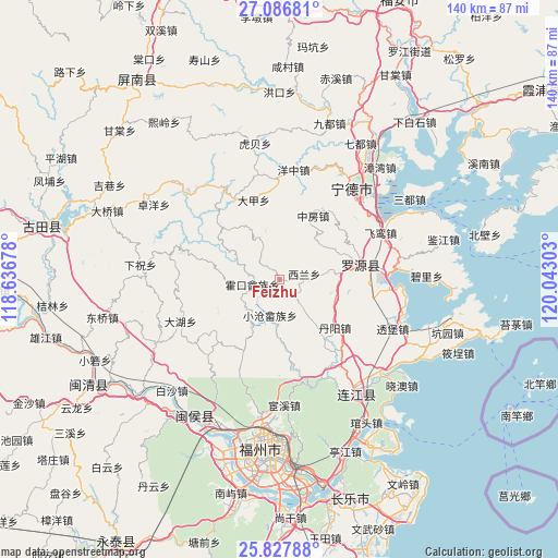
Feizhu GPS coordinates[2]
26° 27' 32.652" North, 119° 20' 23.64" East
| Map corner | latitude | longitude |
|---|---|---|
| Upper-left | 27.08681°, | 118.63678° |
| Center: | 26.45907°, | 119.3399° |
| Lower-right: | 25.82788°, | 120.04303° |
| Map W x H: | 140×140 km | = 87×87mi |
| max Lat: | 53.31946° ⇑80.6% North |
| Feizhu: | 26.45907° |
| min Lat: | ⇓19.4% South 18.22056° |
| min Long | Feizhu | max Long |
| 75.07348° | 119.3399° | 134.28917° |
| W 77.8%⇐ | ⇒22.2% E |
Elevation
Elevation of Feizhu is 389 m = 1276 ft, and this is 95.8 m = 314 ft below average elevation for this country.
| Max E: |
5622 m = 18445 ft | 31.3% |
| Avg. | 484.8 m = 1591 ft | |
| Feizhu | 389 m = 1276 ft | |
Min E: |
-3 m = -10 ft | 68.7% |
See also: China elevation on elevation.city.
Geographical zone
Feizhu is located in North temperate zone (between Tropic of Cancer and the Arctic Circle). Distance of this Northern Tropic circle is 336.1 km =208.8 mi to South.| Distance of | km | miles | from Feizhu |
|---|---|---|---|
| North Pole | 7065.1 | 4390 | to North |
| Arctic Circle | 4459.2 | 2770.8 | to North |
| Tropic Cancer | 336.1 | 208.8 | to South |
| Equator | 2942 | 1828.1 | to South |


Nearby cities:
15 places around Feizhu: (largest is in red/bold)
• Dahu
26.9 km =16.7 mi,  247°
247°
• Dajia
21 km =13 mi,  342°
342°
• Danyang
18.4 km =11.4 mi,  130°
130°
• Fengshan
21 km =13 mi,  81°
81°
• Hongyang
14.4 km =8.9 mi,  57°
57°
• Huokou
6.8 km =4.2 mi,  260°
260°
• Jitoucun
26.5 km =16.5 mi,  85°
85°
• Liaoyan
13 km =8.1 mi,  140°
140°
• Pandu
27.1 km =16.8 mi,  156°
156°
• Qibu
21.1 km =13.1 mi, 75°
• Rixi
13.9 km =8.6 mi,  209°
209°
• Shanyang
27 km =16.8 mi,  330°
330°
• Shoushan
26.1 km =16.2 mi,  203°
203°
• Xilan
4.8 km =3 mi, 80°
• Zhongfang
17.9 km =11.1 mi,  28°
28°
Sources, notices
• [Note1] Compared only with cities in China existing in our database
• [Src1] Map data: © OpenStreetMap contributors (CC-BY-SA)
• [Src2] Other city data from geonames.org with taken over terms of usage.
• [Src3] Geographical zone / Annual Mean Temperature by Robert A. Rohde @ Wikipedia
