Shanyang geodata
Shanyang (Fujian) is a seat of a fourth-order administrative division; located in China in Asia/Shanghai (GMT+8) time zone. With population of 6,810 people, there are 841 cities with bigger population in this country. Compared to other cities in China, 79.8% of cities are located further ↑North; 77% of cities are located further ←West and 78.7% of cities have lower elevation than Shanyang. Note1


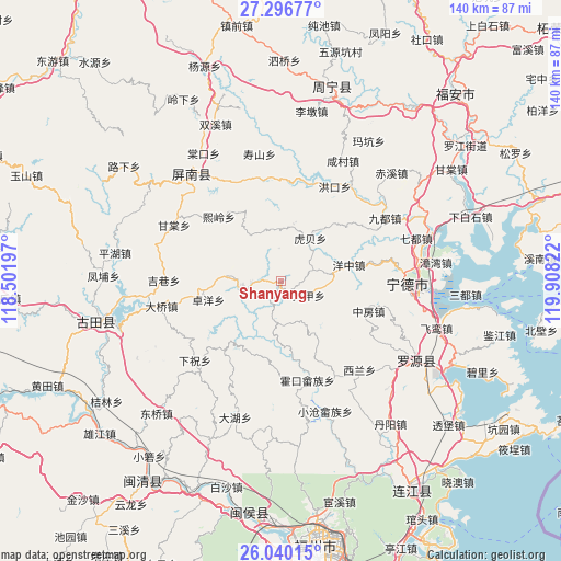
Shanyang GPS coordinates[2]
26° 40' 12.684" North, 119° 12' 18.324" East
| Map corner | latitude | longitude |
|---|---|---|
| Upper-left | 27.29677°, | 118.50197° |
| Center: | 26.67019°, | 119.20509° |
| Lower-right: | 26.04015°, | 119.90822° |
| Map W x H: | 139.7×139.7 km | = 86.8×86.8mi |
| max Lat: | 53.31946° ⇑79.8% North |
| Shanyang: | 26.67019° |
| min Lat: | ⇓20.2% South 18.22056° |
| min Long | Shanyang | max Long |
| 75.07348° | 119.20509° | 134.28917° |
| W 77%⇐ | ⇒23% E |
Elevation
Elevation of Shanyang is 642 m = 2106 ft, and this is 157.2 m = 516 ft above average elevation for this country.
| Max E: |
5622 m = 18445 ft | 21.3% |
| Shanyang | 642 m 2106 ft | |
| Avg. | 484.8 m = 1591 ft | |
Min E: |
-3 m = -10 ft | 78.7% |
See also: China elevation on elevation.city.
Geographical zone
Shanyang is located in North temperate zone (between Tropic of Cancer and the Arctic Circle). Distance of this Northern Tropic circle is 359.5 km =223.4 mi to South.| Distance of | km | miles | from Shanyang |
|---|---|---|---|
| North Pole | 7041.6 | 4375.4 | to North |
| Arctic Circle | 4435.7 | 2756.2 | to North |
| Tropic Cancer | 359.5 | 223.4 | to South |
| Equator | 2965.4 | 1842.6 | to South |


Nearby cities:
15 places around Shanyang: (largest is in red/bold)
• Daixi
18.2 km =11.3 mi,  330°
330°
• Dajia
7.8 km =4.8 mi,  116°
116°
• Feizhu
27 km =16.8 mi,  150°
150°
• Hengyang
29.5 km =18.3 mi,  249°
249°
• Hetang
9.4 km =5.8 mi,  264°
264°
• Huokou
25.5 km =15.8 mi,  164°
164°
• Huotong
29.1 km =18.1 mi,  46°
46°
• Jixiang
29.1 km =18.1 mi,  270°
270°
• Tingping
22.5 km =14 mi,  222°
222°
• Xiazhu
29.1 km =18.1 mi,  227°
227°
• Xilan
29 km =18 mi,  141°
141°
• Xiling
22.4 km =13.9 mi,  315°
315°
• Yangzhong
17.3 km =10.7 mi,  76°
76°
• Zhongfang
23.3 km =14.5 mi,  109°
109°
• Zhuoyang
18.8 km =11.7 mi, 256°
Sources, notices
• [Note1] Compared only with cities in China existing in our database
• [Src1] Map data: © OpenStreetMap contributors (CC-BY-SA)
• [Src2] Other city data from geonames.org with taken over terms of usage.
• [Src3] Geographical zone / Annual Mean Temperature by Robert A. Rohde @ Wikipedia
