Enshi geodata
Enshi (Hubei) is a seat of a second-order administrative division; located in China in Asia/Shanghai (GMT+8) time zone. With population of 95,227 people, there are 446 cities with bigger population in this country. Compared to other cities in China, 51.2% of cities are located further ↑North; 73.9% of cities are located further →East and 71.9% of cities have lower elevation than Enshi. Note1


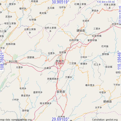
Enshi GPS coordinates[2]
30° 18' 0" North, 109° 28' 59.988" East
| Map corner | latitude | longitude |
|---|---|---|
| Upper-left | 30.90519°, | 108.78021° |
| Center: | 30.3°, | 109.48333° |
| Lower-right: | 29.69105°, | 110.18646° |
| Map W x H: | 135×135 km | = 83.9×83.9mi |
| max Lat: | 53.31946° ⇑51.2% North |
| Enshi: | 30.3° |
| min Lat: | ⇓48.8% South 18.22056° |
| min Long | Enshi | max Long |
| 75.07348° | 109.48333° | 134.28917° |
| W 26.1%⇐ | ⇒73.9% E |
Elevation
Elevation of Enshi is 451 m = 1480 ft, and this is 33.8 m = 111 ft below average elevation for this country.
| Max E: |
5622 m = 18445 ft | 28.1% |
| Avg. | 484.8 m = 1591 ft | |
| Enshi | 451 m = 1480 ft | |
Min E: |
-3 m = -10 ft | 71.9% |
See also: Enshi elevation on elevation.city.
Geographical zone
Enshi is located in North temperate zone (between Tropic of Cancer and the Arctic Circle). Distance of this Northern Tropic circle is 763.1 km =474.2 mi to South.| Distance of | km | miles | from Enshi |
|---|---|---|---|
| North Pole | 6638 | 4124.7 | to North |
| Arctic Circle | 4032.1 | 2505.4 | to North |
| Tropic Cancer | 763.1 | 474.2 | to South |
| Equator | 3369 | 2093.4 | to South |


Nearby cities:
15 places around Enshi: (largest is in red/bold)
• Baiguo
16.5 km =10.3 mi,  240°
240°
• Baiyangping
26.4 km =16.4 mi,  34°
34°
• Jiaoyuan
31.3 km =19.4 mi,  187°
187°
• Liujiaoting
4.3 km =2.7 mi, 193°
• Longfengba
10 km =6.2 mi,  13°
13°
• Nuoxizhi
14.2 km =8.8 mi,  99°
99°
• Sancha
13.5 km =8.4 mi, 101°
• Shadi
26 km =16.2 mi,  80°
80°
• Taiyanghe
33.3 km =20.7 mi,  4°
4°
• Tuanbao
33.7 km =20.9 mi,  276°
276°
• Tunbao
13.5 km =8.4 mi,  309°
309°
• Wanzhai
20.2 km =12.6 mi,  153°
153°
• Wuyangba
3 km =1.9 mi,  168°
168°
• Xiaoduchuan
1.2 km =0.7 mi,  214°
214°
• Xintang
25.9 km =16.1 mi, 96°
Sources, notices
• [Note1] Compared only with cities in China existing in our database
• [Src1] Map data: © OpenStreetMap contributors (CC-BY-SA)
• [Src2] Other city data from geonames.org with taken over terms of usage.
• [Src3] Geographical zone / Annual Mean Temperature by Robert A. Rohde @ Wikipedia
