Xintang geodata
Xintang (Hubei) is a seat of a fourth-order administrative division; located in China in Asia/Shanghai (GMT+8) time zone. In our database, there are 1268 cities with bigger population. Compared to other cities in China, 51.4% of cities are located further ↑North; 72.5% of cities are located further →East and 81.9% of cities have lower elevation than Xintang. Note1


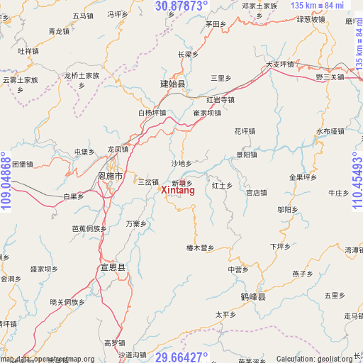
Xintang GPS coordinates[2]
30° 16' 24.168" North, 109° 45' 6.48" East
| Map corner | latitude | longitude |
|---|---|---|
| Upper-left | 30.87873°, | 109.04868° |
| Center: | 30.27338°, | 109.7518° |
| Lower-right: | 29.66427°, | 110.45493° |
| Map W x H: | 135×135 km | = 83.9×83.9mi |
| max Lat: | 53.31946° ⇑51.4% North |
| Xintang: | 30.27338° |
| min Lat: | ⇓48.6% South 18.22056° |
| min Long | Xintang | max Long |
| 75.07348° | 109.7518° | 134.28917° |
| W 27.5%⇐ | ⇒72.5% E |
Elevation
Elevation of Xintang is 785 m = 2575 ft, and this is 300.2 m = 985 ft above average elevation for this country.
| Max E: |
5622 m = 18445 ft | 18.1% |
| Xintang | 785 m 2575 ft | |
| Avg. | 484.8 m = 1591 ft | |
Min E: |
-3 m = -10 ft | 81.9% |
See also: China elevation on elevation.city.
Geographical zone
Xintang is located in North temperate zone (between Tropic of Cancer and the Arctic Circle). Distance of this Northern Tropic circle is 760.2 km =472.4 mi to South.| Distance of | km | miles | from Xintang |
|---|---|---|---|
| North Pole | 6641 | 4126.5 | to North |
| Arctic Circle | 4035.1 | 2507.3 | to North |
| Tropic Cancer | 760.2 | 472.4 | to South |
| Equator | 3366.1 | 2091.6 | to South |


Nearby cities:
15 places around Xintang: (largest is in red/bold)
• Baiyangping
27 km =16.8 mi,  336°
336°
• Chunmuying
25.1 km =15.6 mi,  163°
163°
• Cuijiaba
27.6 km =17.1 mi,  19°
19°
• Enshi
25.9 km =16.1 mi,  276°
276°
• Hongtu
14.9 km =9.3 mi,  94°
94°
• Jingyang
26.3 km =16.3 mi,  66°
66°
• Liujiaoting
26.8 km =16.7 mi,  267°
267°
• Longfengba
26.7 km =16.6 mi,  298°
298°
• Nuoxizhi
11.8 km =7.3 mi, 272°
• Sancha
12.5 km =7.8 mi, 271°
• Shadi
7.1 km =4.4 mi,  358°
358°
• Shangcunba
20.7 km =12.9 mi, 87°
• Wanzhai
22.7 km =14.1 mi,  228°
228°
• Wuyangba
25.2 km =15.7 mi, 270°
• Xiaoduchuan
26.5 km =16.5 mi, 274°
Sources, notices
• [Note1] Compared only with cities in China existing in our database
• [Src1] Map data: © OpenStreetMap contributors (CC-BY-SA)
• [Src2] Other city data from geonames.org with taken over terms of usage.
• [Src3] Geographical zone / Annual Mean Temperature by Robert A. Rohde @ Wikipedia
