Taiyanghe geodata
Taiyanghe (Hubei) is a seat of a fourth-order administrative division; located in China in Asia/Shanghai (GMT+8) time zone. In our database, there are 1268 cities with bigger population. Compared to other cities in China, 51.1% of cities are located further ↓South; 73.8% of cities are located further →East and 81.7% of cities have lower elevation than Taiyanghe. Note1


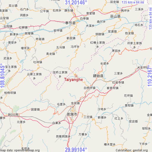
Taiyanghe GPS coordinates[2]
30° 35' 53.304" North, 109° 30' 48.852" East
| Map corner | latitude | longitude |
|---|---|---|
| Upper-left | 31.20146°, | 108.81045° |
| Center: | 30.59814°, | 109.51357° |
| Lower-right: | 29.99104°, | 110.2167° |
| Map W x H: | 134.6×134.6 km | = 83.6×83.6mi |
| max Lat: | 53.31946° ⇑48.9% North |
| Taiyanghe: | 30.59814° |
| min Lat: | ⇓51.1% South 18.22056° |
| min Long | Taiyanghe | max Long |
| 75.07348° | 109.51357° | 134.28917° |
| W 26.2%⇐ | ⇒73.8% E |
Elevation
Elevation of Taiyanghe is 774 m = 2539 ft, and this is 289.2 m = 949 ft above average elevation for this country.
| Max E: |
5622 m = 18445 ft | 18.3% |
| Taiyanghe | 774 m 2539 ft | |
| Avg. | 484.8 m = 1591 ft | |
Min E: |
-3 m = -10 ft | 81.7% |
See also: China elevation on elevation.city.
Geographical zone
Taiyanghe is located in North temperate zone (between Tropic of Cancer and the Arctic Circle). Distance of this Northern Tropic circle is 796.3 km =494.8 mi to South.| Distance of | km | miles | from Taiyanghe |
|---|---|---|---|
| North Pole | 6604.9 | 4104.1 | to North |
| Arctic Circle | 3999 | 2484.9 | to North |
| Tropic Cancer | 796.3 | 494.8 | to South |
| Equator | 3402.2 | 2114 | to South |


Nearby cities:
15 places around Taiyanghe: (largest is in red/bold)
• Baiyangping
16.5 km =10.3 mi,  133°
133°
• Banqiao
22.9 km =14.2 mi,  267°
267°
• Changliang
27.7 km =17.2 mi,  65°
65°
• Chang’an
26.2 km =16.3 mi,  9°
9°
• Fengping
26.3 km =16.3 mi,  358°
358°
• Heshuiping
32.6 km =20.3 mi,  93°
93°
• Longfengba
23.4 km =14.5 mi,  181°
181°
• Longqiao
14.4 km =8.9 mi,  277°
277°
• Miaoyu
32.6 km =20.3 mi,  22°
22°
• Qinglong
31.8 km =19.8 mi,  309°
309°
• Taihe
24.6 km =15.3 mi, 281°
• Tunbao
27.9 km =17.3 mi,  208°
208°
• Wuma
31.3 km =19.4 mi,  335°
335°
• Xinglong
9.2 km =5.7 mi,  315°
315°
• Yezhou
20.1 km =12.5 mi, 88°
Sources, notices
• [Note1] Compared only with cities in China existing in our database
• [Src1] Map data: © OpenStreetMap contributors (CC-BY-SA)
• [Src2] Other city data from geonames.org with taken over terms of usage.
• [Src3] Geographical zone / Annual Mean Temperature by Robert A. Rohde @ Wikipedia
