Longfengba geodata
Longfengba (Hubei) is a seat of a fourth-order administrative division; located in China in Asia/Shanghai (GMT+8) time zone. In our database, there are 1268 cities with bigger population. Compared to other cities in China, 50.5% of cities are located further ↑North; 73.8% of cities are located further →East and 71.8% of cities have lower elevation than Longfengba. Note1


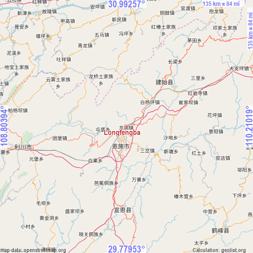
Longfengba GPS coordinates[2]
30° 23' 16.548" North, 109° 30' 25.416" East
| Map corner | latitude | longitude |
|---|---|---|
| Upper-left | 30.99257°, | 108.80394° |
| Center: | 30.38793°, | 109.50706° |
| Lower-right: | 29.77953°, | 110.21019° |
| Map W x H: | 134.9×134.9 km | = 83.8×83.8mi |
| max Lat: | 53.31946° ⇑50.5% North |
| Longfengba: | 30.38793° |
| min Lat: | ⇓49.5% South 18.22056° |
| min Long | Longfengba | max Long |
| 75.07348° | 109.50706° | 134.28917° |
| W 26.2%⇐ | ⇒73.8% E |
Elevation
Elevation of Longfengba is 448 m = 1470 ft, and this is 36.8 m = 121 ft below average elevation for this country.
| Max E: |
5622 m = 18445 ft | 28.2% |
| Avg. | 484.8 m = 1591 ft | |
| Longfengba | 448 m = 1470 ft | |
Min E: |
-3 m = -10 ft | 71.8% |
See also: China elevation on elevation.city.
Geographical zone
Longfengba is located in North temperate zone (between Tropic of Cancer and the Arctic Circle). Distance of this Northern Tropic circle is 772.9 km =480.3 mi to South.| Distance of | km | miles | from Longfengba |
|---|---|---|---|
| North Pole | 6628.2 | 4118.6 | to North |
| Arctic Circle | 4022.4 | 2499.4 | to North |
| Tropic Cancer | 772.9 | 480.3 | to South |
| Equator | 3378.8 | 2099.5 | to South |


Nearby cities:
15 places around Longfengba: (largest is in red/bold)
• Baiguo
24.4 km =15.2 mi,  223°
223°
• Baiyangping
17.4 km =10.8 mi,  46°
46°
• Enshi
10 km =6.2 mi,  193°
193°
• Liujiaoting
14.4 km =8.9 mi, 193°
• Longqiao
28.7 km =17.8 mi,  331°
331°
• Nuoxizhi
16.9 km =10.5 mi,  136°
136°
• Sancha
16.6 km =10.3 mi, 138°
• Shadi
24 km =14.9 mi,  103°
103°
• Taiyanghe
23.4 km =14.5 mi,  1°
1°
• Tunbao
12.7 km =7.9 mi,  264°
264°
• Wanzhai
28.7 km =17.8 mi,  166°
166°
• Wuyangba
12.8 km =8 mi, 187°
• Xiaoduchuan
11.2 km =7 mi,  195°
195°
• Xinglong
30.5 km =19 mi,  348°
348°
• Xintang
26.7 km =16.6 mi,  118°
118°
Sources, notices
• [Note1] Compared only with cities in China existing in our database
• [Src1] Map data: © OpenStreetMap contributors (CC-BY-SA)
• [Src2] Other city data from geonames.org with taken over terms of usage.
• [Src3] Geographical zone / Annual Mean Temperature by Robert A. Rohde @ Wikipedia
