Yangmei geodata
Yangmei (Guangdong) is a seat of a fourth-order administrative division; located in China in Asia/Shanghai (GMT+8) time zone. In our database, there are 1268 cities with bigger population. Compared to other cities in China, 90% of cities are located further ↑North; 59.8% of cities are located further →East and 75.2% of cities have lower elevation than Yangmei. Note1


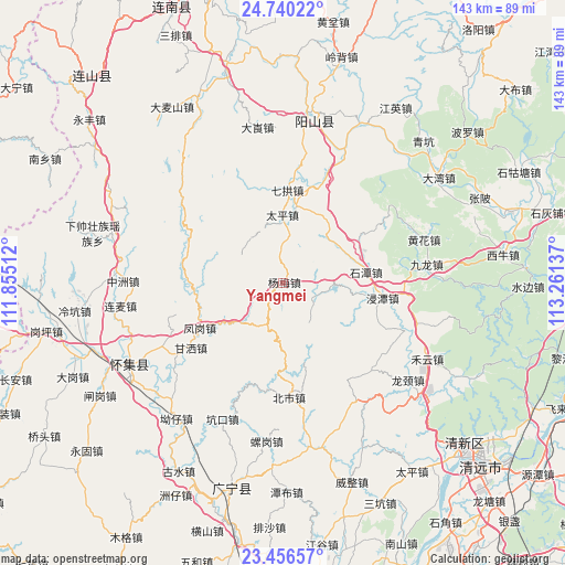
Yangmei GPS coordinates[2]
24° 6' 0" North, 112° 33' 29.664" East
| Map corner | latitude | longitude |
|---|---|---|
| Upper-left | 24.74022°, | 111.85512° |
| Center: | 24.1°, | 112.55824° |
| Lower-right: | 23.45657°, | 113.26137° |
| Map W x H: | 142.7×142.7 km | = 88.7×88.7mi |
| max Lat: | 53.31946° ⇑90% North |
| Yangmei: | 24.1° |
| min Lat: | ⇓10% South 18.22056° |
| min Long | Yangmei | max Long |
| 75.07348° | 112.55824° | 134.28917° |
| W 40.2%⇐ | ⇒59.8% E |
Elevation
Elevation of Yangmei is 527 m = 1729 ft, and this is 42.2 m = 138 ft above average elevation for this country.
| Max E: |
5622 m = 18445 ft | 24.8% |
| Yangmei | 527 m 1729 ft | |
| Avg. | 484.8 m = 1591 ft | |
Min E: |
-3 m = -10 ft | 75.2% |
See also: China elevation on elevation.city.
Geographical zone
Yangmei is located in North temperate zone (between Tropic of Cancer and the Arctic Circle). Distance of this Northern Tropic circle is 73.7 km =45.8 mi to South.| Distance of | km | miles | from Yangmei |
|---|---|---|---|
| North Pole | 7327.4 | 4553 | to North |
| Arctic Circle | 4721.5 | 2933.8 | to North |
| Tropic Cancer | 73.7 | 45.8 | to South |
| Equator | 2679.7 | 1665.1 | to South |


Nearby cities:
15 places around Yangmei: (largest is in red/bold)
• Beishi
29 km =18 mi,  177°
177°
• Chikeng
28.9 km =18 mi,  196°
196°
• Dubu
28.2 km =17.5 mi,  22°
22°
• Fenggang
25 km =15.5 mi,  238°
238°
• Gansa
28.9 km =18 mi, 239°
• Huanghua
36.8 km =22.9 mi,  70°
70°
• Jintan
25.8 km =16 mi,  100°
100°
• Jiulong
35.6 km =22.1 mi,  82°
82°
• Qiashui
23 km =14.3 mi,  266°
266°
• Qigong
22.4 km =13.9 mi,  0°
0°
• Shahe
34.6 km =21.5 mi,  109°
109°
• Shitan
21.1 km =13.1 mi, 81°
• Taiping
17 km =10.6 mi,  358°
358°
• Wenlang
30.9 km =19.2 mi,  245°
245°
• Yanbei
33 km =20.5 mi,  54°
54°
Sources, notices
• [Note1] Compared only with cities in China existing in our database
• [Src1] Map data: © OpenStreetMap contributors (CC-BY-SA)
• [Src2] Other city data from geonames.org with taken over terms of usage.
• [Src3] Geographical zone / Annual Mean Temperature by Robert A. Rohde @ Wikipedia
