Shitan geodata
Shitan (Guangdong) is a seat of a fourth-order administrative division; located in China in Asia/Shanghai (GMT+8) time zone. In our database, there are 1268 cities with bigger population. Compared to other cities in China, 90% of cities are located further ↑North; 58.9% of cities are located further →East and 65.8% of cities have higher elevation than Shitan. Note1


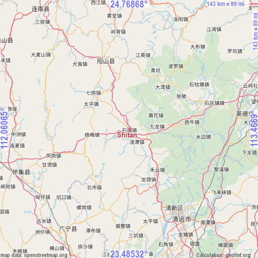
Shitan GPS coordinates[2]
24° 7' 42.996" North, 112° 45' 49.572" East
| Map corner | latitude | longitude |
|---|---|---|
| Upper-left | 24.76868°, | 112.06065° |
| Center: | 24.12861°, | 112.76377° |
| Lower-right: | 23.48532°, | 113.4669° |
| Map W x H: | 142.7×142.7 km | = 88.7×88.7mi |
| max Lat: | 53.31946° ⇑90% North |
| Shitan: | 24.12861° |
| min Lat: | ⇓10% South 18.22056° |
| min Long | Shitan | max Long |
| 75.07348° | 112.76377° | 134.28917° |
| W 41.1%⇐ | ⇒58.9% E |
Elevation
Elevation of Shitan is 69 m = 226 ft, and this is 415.8 m = 1364 ft below average elevation for this country.
| Max E: |
5622 m = 18445 ft | 65.8% |
| Avg. | 484.8 m = 1591 ft | |
| Shitan | 69 m = 226 ft | |
Min E: |
-3 m = -10 ft | 34.2% |
See also: China elevation on elevation.city.
Geographical zone
Shitan is located in North temperate zone (between Tropic of Cancer and the Arctic Circle). Distance of this Northern Tropic circle is 76.9 km =47.8 mi to South.| Distance of | km | miles | from Shitan |
|---|---|---|---|
| North Pole | 7324.2 | 4551 | to North |
| Arctic Circle | 4718.3 | 2931.8 | to North |
| Tropic Cancer | 76.9 | 47.8 | to South |
| Equator | 2682.8 | 1667 | to South |


Nearby cities:
15 places around Shitan: (largest is in red/bold)
• Dadong
32.9 km =20.4 mi,  109°
109°
• Dawan
29.5 km =18.3 mi,  36°
36°
• Dubu
24.8 km =15.4 mi,  336°
336°
• Heyun
27.1 km =16.8 mi,  144°
144°
• Huanghua
16.6 km =10.3 mi,  57°
57°
• Jintan
8.9 km =5.5 mi,  149°
149°
• Jiulong
14.5 km =9 mi,  85°
85°
• Longjing
29.8 km =18.5 mi,  165°
165°
• Mingjing
16.6 km =10.3 mi, 60°
• Qigong
28.4 km =17.6 mi,  312°
312°
• Shaba
32.5 km =20.2 mi,  97°
97°
• Shahe
19 km =11.8 mi, 141°
• Taiping
25.3 km =15.7 mi,  302°
302°
• Yanbei
17.2 km =10.7 mi,  20°
20°
• Yangmei
21.1 km =13.1 mi,  261°
261°
Sources, notices
• [Note1] Compared only with cities in China existing in our database
• [Src1] Map data: © OpenStreetMap contributors (CC-BY-SA)
• [Src2] Other city data from geonames.org with taken over terms of usage.
• [Src3] Geographical zone / Annual Mean Temperature by Robert A. Rohde @ Wikipedia
