Donghenan geodata
Donghenan (Shanxi) is a seat of a fourth-order administrative division; located in China in Asia/Shanghai (GMT+8) time zone. In our database, there are 1268 cities with bigger population. Compared to other cities in China, 84.3% of cities are located further ↓South; 51.1% of cities are located further →East and 86% of cities have lower elevation than Donghenan. Note1


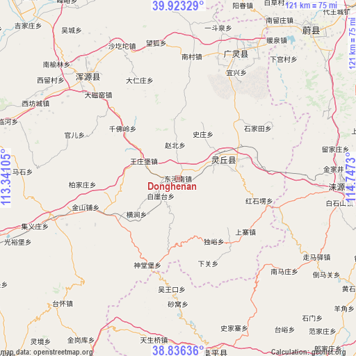
Donghenan GPS coordinates[2]
39° 22' 54.984" North, 114° 2' 39.012" East
| Map corner | latitude | longitude |
|---|---|---|
| Upper-left | 39.92329°, | 113.34105° |
| Center: | 39.38194°, | 114.04417° |
| Lower-right: | 38.83636°, | 114.7473° |
| Map W x H: | 120.9×120.9 km | = 75.1×75.1mi |
| max Lat: | 53.31946° ⇑15.7% North |
| Donghenan: | 39.38194° |
| min Lat: | ⇓84.3% South 18.22056° |
| min Long | Donghenan | max Long |
| 75.07348° | 114.04417° | 134.28917° |
| W 48.9%⇐ | ⇒51.1% E |
Elevation
Elevation of Donghenan is 1044 m = 3425 ft, and this is 559.2 m = 1835 ft above average elevation for this country.
| Max E: |
5622 m = 18445 ft | 14% |
| Donghenan | 1044 m 3425 ft | |
| Avg. | 484.8 m = 1591 ft | |
Min E: |
-3 m = -10 ft | 86% |
See also: China elevation on elevation.city.
Geographical zone
Donghenan is located in North temperate zone (between Tropic of Cancer and the Arctic Circle). Distance of this Northern Tropic circle is 1772.9 km =1101.6 mi to South.| Distance of | km | miles | from Donghenan |
|---|---|---|---|
| North Pole | 5628.2 | 3497.2 | to North |
| Arctic Circle | 3022.3 | 1878 | to North |
| Tropic Cancer | 1772.9 | 1101.6 | to South |
| Equator | 4378.9 | 2720.9 | to South |


Nearby cities:
15 places around Donghenan: (largest is in red/bold)
• Baijiazhuang
32.5 km =20.2 mi,  266°
266°
• Baiyatai
8.5 km =5.3 mi,  225°
225°
• Darenzhuang
36.1 km =22.4 mi,  338°
338°
• Daying
26.7 km =16.6 mi,  247°
247°
• Guan’er
38.1 km =23.7 mi,  292°
292°
• Hengjian
18.6 km =11.6 mi, 229°
• Huanghuatan
34.8 km =21.6 mi,  330°
330°
• Jinshanpu
32.9 km =20.4 mi, 252°
• Qianfoling
25.3 km =15.7 mi,  312°
312°
• Qingciyao
35.5 km =22.1 mi,  318°
318°
• Shentangbao
31.2 km =19.4 mi,  199°
199°
• Wangzhuangbu
13 km =8.1 mi,  297°
297°
• Wuling
13.1 km =8.1 mi,  43°
43°
• Wuwangkou
37.5 km =23.3 mi,  183°
183°
• Zhaobei
11.4 km =7.1 mi,  355°
355°
Sources, notices
• [Note1] Compared only with cities in China existing in our database
• [Src1] Map data: © OpenStreetMap contributors (CC-BY-SA)
• [Src2] Other city data from geonames.org with taken over terms of usage.
• [Src3] Geographical zone / Annual Mean Temperature by Robert A. Rohde @ Wikipedia
