Huanghuatan geodata
Huanghuatan (Shanxi) is a seat of a fourth-order administrative division; located in China in Asia/Shanghai (GMT+8) time zone. In our database, there are 1268 cities with bigger population. Compared to other cities in China, 85.1% of cities are located further ↓South; 52.3% of cities are located further →East and 92.1% of cities have lower elevation than Huanghuatan. Note1


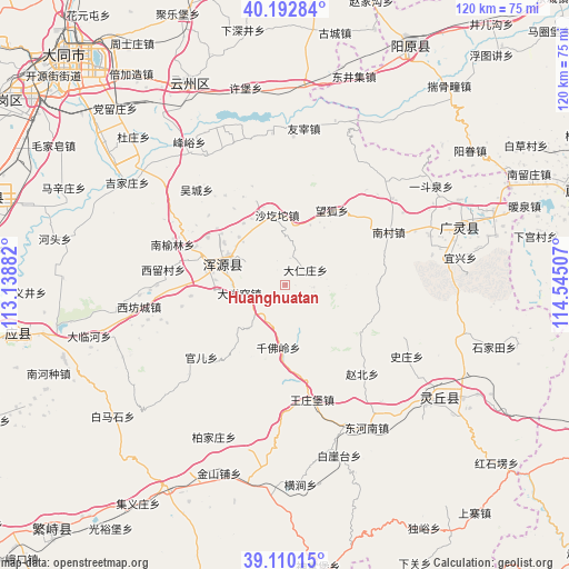
Huanghuatan GPS coordinates[2]
39° 39' 12.996" North, 113° 50' 30.984" East
| Map corner | latitude | longitude |
|---|---|---|
| Upper-left | 40.19284°, | 113.13882° |
| Center: | 39.65361°, | 113.84194° |
| Lower-right: | 39.11015°, | 114.54507° |
| Map W x H: | 120.4×120.4 km | = 74.8×74.8mi |
| max Lat: | 53.31946° ⇑14.9% North |
| Huanghuatan: | 39.65361° |
| min Lat: | ⇓85.1% South 18.22056° |
| min Long | Huanghuatan | max Long |
| 75.07348° | 113.84194° | 134.28917° |
| W 47.7%⇐ | ⇒52.3% E |
Elevation
Elevation of Huanghuatan is 1588 m = 5210 ft, and this is 1103.2 m = 3619 ft above average elevation for this country.
| Max E: |
5622 m = 18445 ft | 7.9% |
| Huanghuatan | 1588 m 5210 ft | |
| Avg. | 484.8 m = 1591 ft | |
Min E: |
-3 m = -10 ft | 92.1% |
See also: China elevation on elevation.city.
Geographical zone
Huanghuatan is located in North temperate zone (between Tropic of Cancer and the Arctic Circle). Distance of this Northern Tropic circle is 1803.1 km =1120.4 mi to South.| Distance of | km | miles | from Huanghuatan |
|---|---|---|---|
| North Pole | 5598 | 3478.4 | to North |
| Arctic Circle | 2992.1 | 1859.2 | to North |
| Tropic Cancer | 1803.1 | 1120.4 | to South |
| Equator | 4409.1 | 2739.7 | to South |


Nearby cities:
15 places around Huanghuatan: (largest is in red/bold)
• Caicun
19.3 km =12 mi,  301°
301°
• Daciyao
9.8 km =6.1 mi,  259°
259°
• Darenzhuang
5.3 km =3.3 mi,  50°
50°
• Guan’er
23.4 km =14.5 mi,  229°
229°
• Nanyulin
25.5 km =15.8 mi,  292°
292°
• Qianfoling
13.3 km =8.3 mi,  186°
186°
• Qingciyao
7.4 km =4.6 mi,  239°
239°
• Wanghu
18.6 km =11.6 mi,  32°
32°
• Wangzhuangbu
24.9 km =15.5 mi,  166°
166°
• Wucheng
27.5 km =17.1 mi,  317°
317°
• Xiahan
21 km =13 mi, 292°
• Xiliu
26 km =16.2 mi,  277°
277°
• Xinpeicun
27.1 km =16.8 mi, 261°
• Yong’an
14.1 km =8.8 mi, 289°
• Zhaobei
24.9 km =15.5 mi,  138°
138°
Sources, notices
• [Note1] Compared only with cities in China existing in our database
• [Src1] Map data: © OpenStreetMap contributors (CC-BY-SA)
• [Src2] Other city data from geonames.org with taken over terms of usage.
• [Src3] Geographical zone / Annual Mean Temperature by Robert A. Rohde @ Wikipedia
