Shentangbao geodata
Shentangbao (Shanxi) is a seat of a fourth-order administrative division; located in China in Asia/Shanghai (GMT+8) time zone. In our database, there are 1268 cities with bigger population. Compared to other cities in China, 83.3% of cities are located further ↓South; 51.9% of cities are located further →East and 81.7% of cities have lower elevation than Shentangbao. Note1


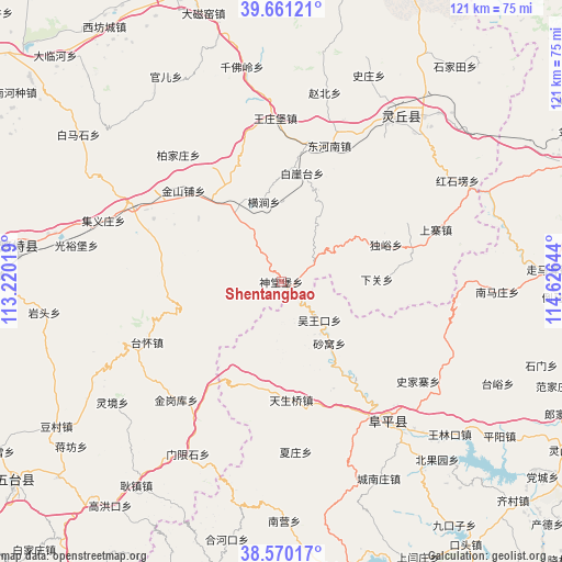
Shentangbao GPS coordinates[2]
39° 7' 4.08" North, 113° 55' 23.916" East
| Map corner | latitude | longitude |
|---|---|---|
| Upper-left | 39.66121°, | 113.22019° |
| Center: | 39.1178°, | 113.92331° |
| Lower-right: | 38.57017°, | 114.62644° |
| Map W x H: | 121.3×121.3 km | = 75.4×75.4mi |
| max Lat: | 53.31946° ⇑16.7% North |
| Shentangbao: | 39.1178° |
| min Lat: | ⇓83.3% South 18.22056° |
| min Long | Shentangbao | max Long |
| 75.07348° | 113.92331° | 134.28917° |
| W 48.1%⇐ | ⇒51.9% E |
Elevation
Elevation of Shentangbao is 773 m = 2536 ft, and this is 288.2 m = 946 ft above average elevation for this country.
| Max E: |
5622 m = 18445 ft | 18.3% |
| Shentangbao | 773 m 2536 ft | |
| Avg. | 484.8 m = 1591 ft | |
Min E: |
-3 m = -10 ft | 81.7% |
See also: China elevation on elevation.city.
Geographical zone
Shentangbao is located in North temperate zone (between Tropic of Cancer and the Arctic Circle). Distance of this Northern Tropic circle is 1743.6 km =1083.4 mi to South.| Distance of | km | miles | from Shentangbao |
|---|---|---|---|
| North Pole | 5657.6 | 3515.5 | to North |
| Arctic Circle | 3051.7 | 1896.2 | to North |
| Tropic Cancer | 1743.6 | 1083.4 | to South |
| Equator | 4349.5 | 2702.7 | to South |


Nearby cities:
15 places around Shentangbao: (largest is in red/bold)
• Baijiazhuang
35.2 km =21.9 mi,  321°
321°
• Baiyatai
23.8 km =14.8 mi,  10°
10°
• Datai
41.7 km =25.9 mi,  111°
111°
• Daying
23.9 km =14.9 mi, 323°
• Donghenan
31.2 km =19.4 mi,  19°
19°
• Hengjian
17.6 km =10.9 mi,  347°
347°
• Jinshanpu
28.8 km =17.9 mi,  313°
313°
• Jiyizhuang
40.5 km =25.2 mi,  289°
289°
• Shahe
36.6 km =22.7 mi,  297°
297°
• Shawo
16.8 km =10.4 mi,  142°
142°
• Shijiazhai
36.6 km =22.7 mi,  125°
125°
• Wangzhuangbu
35.3 km =21.9 mi,  358°
358°
• Wuwangkou
11.5 km =7.1 mi, 134°
• Yanglinjie
31.1 km =19.3 mi,  247°
247°
• Zhaobei
41.8 km =26 mi, 13°
Sources, notices
• [Note1] Compared only with cities in China existing in our database
• [Src1] Map data: © OpenStreetMap contributors (CC-BY-SA)
• [Src2] Other city data from geonames.org with taken over terms of usage.
• [Src3] Geographical zone / Annual Mean Temperature by Robert A. Rohde @ Wikipedia
