Dongdai geodata
Dongdai (Fujian) is a seat of a fourth-order administrative division; located in China in Asia/Shanghai (GMT+8) time zone. With population of 8,240 people, there are 827 cities with bigger population in this country. Compared to other cities in China, 81.4% of cities are located further ↑North; 79.5% of cities are located further ←West and 86.9% of cities have higher elevation than Dongdai. Note1


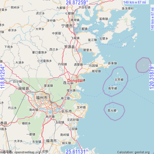
Dongdai GPS coordinates[2]
26° 14' 37.176" North, 119° 36' 56.376" East
| Map corner | latitude | longitude |
|---|---|---|
| Upper-left | 26.87259°, | 118.91254° |
| Center: | 26.24366°, | 119.61566° |
| Lower-right: | 25.61131°, | 120.31879° |
| Map W x H: | 140.2×140.2 km | = 87.1×87.1mi |
| max Lat: | 53.31946° ⇑81.4% North |
| Dongdai: | 26.24366° |
| min Lat: | ⇓18.6% South 18.22056° |
| min Long | Dongdai | max Long |
| 75.07348° | 119.61566° | 134.28917° |
| W 79.5%⇐ | ⇒20.5% E |
Elevation
Elevation of Dongdai is 13 m = 43 ft, and this is 471.8 m = 1548 ft below average elevation for this country.
| Max E: |
5622 m = 18445 ft | 86.9% |
| Avg. | 484.8 m = 1591 ft | |
| Dongdai | 13 m = 43 ft | |
Min E: |
-3 m = -10 ft | 13.1% |
See also: China elevation on elevation.city.
Geographical zone
Dongdai is located in North temperate zone (between Tropic of Cancer and the Arctic Circle). Distance of this Northern Tropic circle is 312.1 km =193.9 mi to South.| Distance of | km | miles | from Dongdai |
|---|---|---|---|
| North Pole | 7089 | 4404.9 | to North |
| Arctic Circle | 4483.2 | 2785.7 | to North |
| Tropic Cancer | 312.1 | 193.9 | to South |
| Equator | 2918 | 1813.2 | to South |


Nearby cities:
15 places around Dongdai: (largest is in red/bold)
• Aojiang
9.3 km =5.8 mi,  239°
239°
• Changlong
9.6 km =6 mi,  331°
331°
• Dinghaicun
17.8 km =11.1 mi,  76°
76°
• Donghu
10.2 km =6.3 mi,  264°
264°
• Fengcheng
9.2 km =5.7 mi, 235°
• Guanban
9.3 km =5.8 mi,  35°
35°
• Guantou
13.1 km =8.1 mi,  204°
204°
• Jiangnan
9.6 km =6 mi,  234°
234°
• Langqi
17.8 km =11.1 mi,  194°
194°
• Mabi
15.2 km =9.4 mi,  15°
15°
• Pandu
16.5 km =10.3 mi,  267°
267°
• Pukou
1.8 km =1.1 mi,  286°
286°
• Toubao
11.7 km =7.3 mi,  4°
4°
• Xiaocheng
17.8 km =11.1 mi,  71°
71°
• Xiao’ao
4.2 km =2.6 mi,  127°
127°
Sources, notices
• [Note1] Compared only with cities in China existing in our database
• [Src1] Map data: © OpenStreetMap contributors (CC-BY-SA)
• [Src2] Other city data from geonames.org with taken over terms of usage.
• [Src3] Geographical zone / Annual Mean Temperature by Robert A. Rohde @ Wikipedia
