Fengcheng geodata
Fengcheng (Fujian) is a seat of a third-order administrative division; located in China in Asia/Shanghai (GMT+8) time zone. In our database, there are 1268 cities with bigger population. Compared to other cities in China, 81.5% of cities are located further ↑North; 79.1% of cities are located further ←West and 85.5% of cities have higher elevation than Fengcheng. Note1


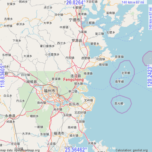
Fengcheng GPS coordinates[2]
26° 11' 49.992" North, 119° 32' 21.012" East
| Map corner | latitude | longitude |
|---|---|---|
| Upper-left | 26.8264°, | 118.83605° |
| Center: | 26.19722°, | 119.53917° |
| Lower-right: | 25.56462°, | 120.2423° |
| Map W x H: | 140.3×140.3 km | = 87.2×87.2mi |
| max Lat: | 53.31946° ⇑81.5% North |
| Fengcheng: | 26.19722° |
| min Lat: | ⇓18.5% South 18.22056° |
| min Long | Fengcheng | max Long |
| 75.07348° | 119.53917° | 134.28917° |
| W 79.1%⇐ | ⇒20.9% E |
Elevation
Elevation of Fengcheng is 15 m = 49 ft, and this is 469.8 m = 1541 ft below average elevation for this country.
| Max E: |
5622 m = 18445 ft | 85.5% |
| Avg. | 484.8 m = 1591 ft | |
| Fengcheng | 15 m = 49 ft | |
Min E: |
-3 m = -10 ft | 14.5% |
See also: China elevation on elevation.city.
Geographical zone
Fengcheng is located in North temperate zone (between Tropic of Cancer and the Arctic Circle). Distance of this Northern Tropic circle is 306.9 km =190.7 mi to South.| Distance of | km | miles | from Fengcheng |
|---|---|---|---|
| North Pole | 7094.2 | 4408.1 | to North |
| Arctic Circle | 4488.3 | 2788.9 | to North |
| Tropic Cancer | 306.9 | 190.7 | to South |
| Equator | 2912.9 | 1810 | to South |


Nearby cities:
15 places around Fengcheng: (largest is in red/bold)
• Aojiang
0.6 km =0.4 mi,  323°
323°
• Changlong
13.9 km =8.6 mi,  12°
12°
• Danyang
18.1 km =11.2 mi,  341°
341°
• Dongdai
9.2 km =5.7 mi,  55°
55°
• Donghu
4.8 km =3 mi,  329°
329°
• Guanban
18.2 km =11.3 mi,  45°
45°
• Guantou
7.2 km =4.5 mi,  161°
161°
• Houyu
15.3 km =9.5 mi,  181°
181°
• Jiangnan
0.5 km =0.3 mi,  197°
197°
• Langqi
12.5 km =7.8 mi,  165°
165°
• Min’an
16.9 km =10.5 mi,  193°
193°
• Pandu
9.9 km =6.2 mi,  296°
296°
• Pukou
8.2 km =5.1 mi, 45°
• Tingjiang
14.1 km =8.8 mi, 193°
• Xiao’ao
11.2 km =7 mi,  76°
76°
Sources, notices
• [Note1] Compared only with cities in China existing in our database
• [Src1] Map data: © OpenStreetMap contributors (CC-BY-SA)
• [Src2] Other city data from geonames.org with taken over terms of usage.
• [Src3] Geographical zone / Annual Mean Temperature by Robert A. Rohde @ Wikipedia
