Langqi geodata
Langqi (Fujian) is a seat of a fourth-order administrative division; located in China in Asia/Shanghai (GMT+8) time zone. In our database, there are 1268 cities with bigger population. Compared to other cities in China, 82% of cities are located further ↑North; 79.3% of cities are located further ←West and 86.2% of cities have higher elevation than Langqi. Note1


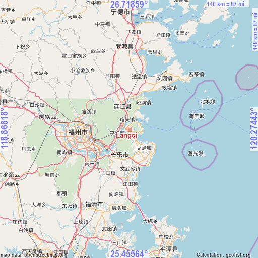
Langqi GPS coordinates[2]
26° 5' 19.752" North, 119° 34' 16.68" East
| Map corner | latitude | longitude |
|---|---|---|
| Upper-left | 26.71859°, | 118.86818° |
| Center: | 26.08882°, | 119.5713° |
| Lower-right: | 25.45564°, | 120.27443° |
| Map W x H: | 140.4×140.4 km | = 87.2×87.2mi |
| max Lat: | 53.31946° ⇑82% North |
| Langqi: | 26.08882° |
| min Lat: | ⇓18% South 18.22056° |
| min Long | Langqi | max Long |
| 75.07348° | 119.5713° | 134.28917° |
| W 79.3%⇐ | ⇒20.7% E |
Elevation
Elevation of Langqi is 14 m = 46 ft, and this is 470.8 m = 1545 ft below average elevation for this country.
| Max E: |
5622 m = 18445 ft | 86.2% |
| Avg. | 484.8 m = 1591 ft | |
| Langqi | 14 m = 46 ft | |
Min E: |
-3 m = -10 ft | 13.8% |
See also: China elevation on elevation.city.
Geographical zone
Langqi is located in North temperate zone (between Tropic of Cancer and the Arctic Circle). Distance of this Northern Tropic circle is 294.9 km =183.2 mi to South.| Distance of | km | miles | from Langqi |
|---|---|---|---|
| North Pole | 7106.3 | 4415.6 | to North |
| Arctic Circle | 4500.4 | 2796.4 | to North |
| Tropic Cancer | 294.9 | 183.2 | to South |
| Equator | 2900.8 | 1802.5 | to South |


Nearby cities:
15 places around Langqi: (largest is in red/bold)
• Aojiang
13 km =8.1 mi,  344°
344°
• Donghu
17.2 km =10.7 mi, 340°
• Fengcheng
12.5 km =7.8 mi,  345°
345°
• Guantou
5.3 km =3.3 mi, 349°
• Heshang
15.6 km =9.7 mi,  188°
188°
• Houyu
4.9 km =3 mi,  228°
228°
• Hunan
15 km =9.3 mi,  150°
150°
• Jiangnan
12.1 km =7.5 mi, 343°
• Jinfeng
13.3 km =8.3 mi,  157°
157°
• Kuai’an
16.6 km =10.3 mi,  248°
248°
• Min’an
8.4 km =5.2 mi,  238°
238°
• Tantou
7 km =4.3 mi, 158°
• Tingjiang
6.8 km =4.2 mi,  255°
255°
• Wenling
12.9 km =8 mi,  142°
142°
• Xiao’ao
16.6 km =10.3 mi,  27°
27°
Sources, notices
• [Note1] Compared only with cities in China existing in our database
• [Src1] Map data: © OpenStreetMap contributors (CC-BY-SA)
• [Src2] Other city data from geonames.org with taken over terms of usage.
• [Src3] Geographical zone / Annual Mean Temperature by Robert A. Rohde @ Wikipedia
