Dinghaicun geodata
Dinghaicun (Fujian) is a populated place; located in China in Asia/Shanghai (GMT+8) time zone. With population of 7,620 people, there are 832 cities with bigger population in this country. Compared to other cities in China, 81.2% of cities are located further ↑North; 80.6% of cities are located further ←West and 86.2% of cities have higher elevation than Dinghaicun. Note1


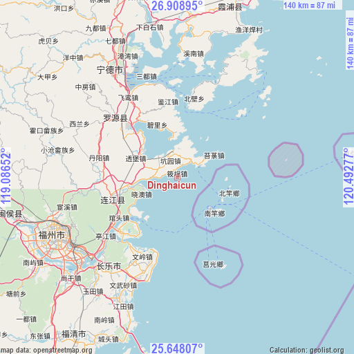
Dinghaicun GPS coordinates[2]
26° 16' 48.792" North, 119° 47' 22.704" East
| Map corner | latitude | longitude |
|---|---|---|
| Upper-left | 26.90895°, | 119.08652° |
| Center: | 26.28022°, | 119.78964° |
| Lower-right: | 25.64807°, | 120.49277° |
| Map W x H: | 140.2×140.2 km | = 87.1×87.1mi |
| max Lat: | 53.31946° ⇑81.2% North |
| Dinghaicun: | 26.28022° |
| min Lat: | ⇓18.8% South 18.22056° |
| min Long | Dinghaicun | max Long |
| 75.07348° | 119.78964° | 134.28917° |
| W 80.6%⇐ | ⇒19.4% E |
Elevation
Elevation of Dinghaicun is 14 m = 46 ft, and this is 470.8 m = 1545 ft below average elevation for this country.
| Max E: |
5622 m = 18445 ft | 86.2% |
| Avg. | 484.8 m = 1591 ft | |
| Dinghaicun | 14 m = 46 ft | |
Min E: |
-3 m = -10 ft | 13.8% |
See also: China elevation on elevation.city.
Geographical zone
Dinghaicun is located in North temperate zone (between Tropic of Cancer and the Arctic Circle). Distance of this Northern Tropic circle is 316.2 km =196.5 mi to South.| Distance of | km | miles | from Dinghaicun |
|---|---|---|---|
| North Pole | 7085 | 4402.4 | to North |
| Arctic Circle | 4479.1 | 2783.2 | to North |
| Tropic Cancer | 316.2 | 196.5 | to South |
| Equator | 2922.1 | 1815.7 | to South |


Nearby cities:
15 places around Dinghaicun: (largest is in red/bold)
• Ankai
8.5 km =5.3 mi,  36°
36°
• Beishancun
23.4 km =14.5 mi,  318°
318°
• Changlong
22.4 km =13.9 mi,  281°
281°
• Dongdai
17.8 km =11.1 mi,  256°
256°
• Guanban
12.5 km =7.8 mi,  286°
286°
• Huangqi
10.6 km =6.6 mi,  62°
62°
• Kengyuan
7.1 km =4.4 mi,  339°
339°
• Lian’aocun
18.5 km =11.5 mi,  359°
359°
• Mabi
17 km =10.6 mi,  308°
308°
• Pukou
19.4 km =12.1 mi, 259°
• Tailu
17 km =10.6 mi, 58°
• Toubao
18 km =11.2 mi, 294°
• Xiagong
11.5 km =7.1 mi,  2°
2°
• Xiaocheng
1.6 km =1 mi, 344°
• Xiao’ao
15.5 km =9.6 mi,  244°
244°
Sources, notices
• [Note1] Compared only with cities in China existing in our database
• [Src1] Map data: © OpenStreetMap contributors (CC-BY-SA)
• [Src2] Other city data from geonames.org with taken over terms of usage.
• [Src3] Geographical zone / Annual Mean Temperature by Robert A. Rohde @ Wikipedia
