Dongchongcun geodata
Dongchongcun (Fujian) is a populated place; located in China in Asia/Shanghai (GMT+8) time zone. With population of 2,440 people, there are 990 cities with bigger population in this country. Compared to other cities in China, 80.3% of cities are located further ↑North; 80.8% of cities are located further ←West and 86.2% of cities have higher elevation than Dongchongcun. Note1


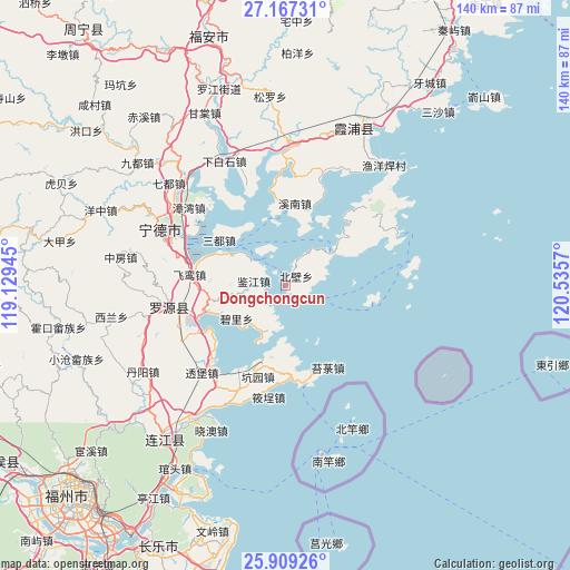
Dongchongcun GPS coordinates[2]
26° 32' 24.036" North, 119° 49' 57.252" East
| Map corner | latitude | longitude |
|---|---|---|
| Upper-left | 27.16731°, | 119.12945° |
| Center: | 26.54001°, | 119.83257° |
| Lower-right: | 25.90926°, | 120.5357° |
| Map W x H: | 139.9×139.9 km | = 86.9×86.9mi |
| max Lat: | 53.31946° ⇑80.3% North |
| Dongchongcun: | 26.54001° |
| min Lat: | ⇓19.7% South 18.22056° |
| min Long | Dongchongcun | max Long |
| 75.07348° | 119.83257° | 134.28917° |
| W 80.8%⇐ | ⇒19.2% E |
Elevation
Elevation of Dongchongcun is 14 m = 46 ft, and this is 470.8 m = 1545 ft below average elevation for this country.
| Max E: |
5622 m = 18445 ft | 86.2% |
| Avg. | 484.8 m = 1591 ft | |
| Dongchongcun | 14 m = 46 ft | |
Min E: |
-3 m = -10 ft | 13.8% |
See also: China elevation on elevation.city.
Geographical zone
Dongchongcun is located in North temperate zone (between Tropic of Cancer and the Arctic Circle). Distance of this Northern Tropic circle is 345.1 km =214.4 mi to South.| Distance of | km | miles | from Dongchongcun |
|---|---|---|---|
| North Pole | 7056.1 | 4384.5 | to North |
| Arctic Circle | 4450.2 | 2765.2 | to North |
| Tropic Cancer | 345.1 | 214.4 | to South |
| Equator | 2951 | 1833.7 | to South |


Nearby cities:
15 places around Dongchongcun: (largest is in red/bold)
• Ankai
22 km =13.7 mi,  177°
177°
• Beishancun
22.8 km =14.2 mi,  240°
240°
• Feiluan
23.5 km =14.6 mi,  276°
276°
• Haidao
21.8 km =13.5 mi,  100°
100°
• Huangqi
24.5 km =15.2 mi,  168°
168°
• Jianjiang
7.8 km =4.8 mi, 277°
• Jitoucun
23.7 km =14.7 mi,  252°
252°
• Kengyuan
23.3 km =14.5 mi,  196°
196°
• Lian’aocun
11.4 km =7.1 mi, 203°
• Mabi
25.4 km =15.8 mi,  223°
223°
• Songqi
19.6 km =12.2 mi,  304°
304°
• Tailu
22.5 km =14 mi,  153°
153°
• Xiagong
17.8 km =11.1 mi,  192°
192°
• Xiahu
13.9 km =8.6 mi,  55°
55°
• Xinan
20.1 km =12.5 mi,  6°
6°
Sources, notices
• [Note1] Compared only with cities in China existing in our database
• [Src1] Map data: © OpenStreetMap contributors (CC-BY-SA)
• [Src2] Other city data from geonames.org with taken over terms of usage.
• [Src3] Geographical zone / Annual Mean Temperature by Robert A. Rohde @ Wikipedia
