Ankai geodata
Ankai (Fujian) is a seat of a fourth-order administrative division; located in China in Asia/Shanghai (GMT+8) time zone. In our database, there are 1268 cities with bigger population. Compared to other cities in China, 81% of cities are located further ↑North; 80.8% of cities are located further ←West and 62.1% of cities have higher elevation than Ankai. Note1


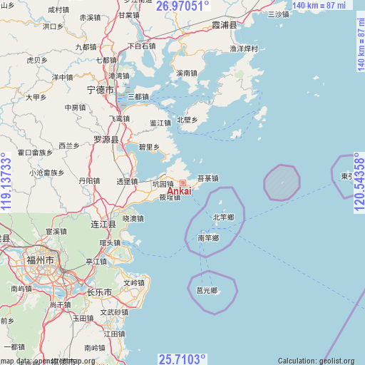
Ankai GPS coordinates[2]
26° 20' 31.632" North, 119° 50' 25.62" East
| Map corner | latitude | longitude |
|---|---|---|
| Upper-left | 26.97051°, | 119.13733° |
| Center: | 26.34212°, | 119.84045° |
| Lower-right: | 25.7103°, | 120.54358° |
| Map W x H: | 140.1×140.1 km | = 87.1×87.1mi |
| max Lat: | 53.31946° ⇑81% North |
| Ankai: | 26.34212° |
| min Lat: | ⇓19% South 18.22056° |
| min Long | Ankai | max Long |
| 75.07348° | 119.84045° | 134.28917° |
| W 80.8%⇐ | ⇒19.2% E |
Elevation
Elevation of Ankai is 87 m = 285 ft, and this is 397.8 m = 1305 ft below average elevation for this country.
| Max E: |
5622 m = 18445 ft | 62.1% |
| Avg. | 484.8 m = 1591 ft | |
| Ankai | 87 m = 285 ft | |
Min E: |
-3 m = -10 ft | 37.9% |
See also: China elevation on elevation.city.
Geographical zone
Ankai is located in North temperate zone (between Tropic of Cancer and the Arctic Circle). Distance of this Northern Tropic circle is 323.1 km =200.8 mi to South.| Distance of | km | miles | from Ankai |
|---|---|---|---|
| North Pole | 7078.1 | 4398.1 | to North |
| Arctic Circle | 4472.2 | 2778.9 | to North |
| Tropic Cancer | 323.1 | 200.8 | to South |
| Equator | 2929 | 1820 | to South |


Nearby cities:
15 places around Ankai: (largest is in red/bold)
• Beishancun
23.2 km =14.4 mi,  297°
297°
• Dinghaicun
8.5 km =5.3 mi,  216°
216°
• Dongchongcun
22 km =13.7 mi,  357°
357°
• Dongdai
24.9 km =15.5 mi,  243°
243°
• Guanban
17.3 km =10.7 mi,  258°
258°
• Huangqi
4.8 km =3 mi,  115°
115°
• Jianjiang
24.6 km =15.3 mi,  339°
339°
• Kengyuan
7.5 km =4.7 mi,  267°
267°
• Lian’aocun
12.8 km =8 mi, 335°
• Mabi
18.7 km =11.6 mi,  281°
281°
• Tailu
9.6 km =6 mi,  78°
78°
• Toubao
21.4 km =13.3 mi, 271°
• Xiagong
6.5 km =4 mi,  315°
315°
• Xiaocheng
7.6 km =4.7 mi,  225°
225°
• Xiao’ao
23.4 km =14.5 mi, 234°
Sources, notices
• [Note1] Compared only with cities in China existing in our database
• [Src1] Map data: © OpenStreetMap contributors (CC-BY-SA)
• [Src2] Other city data from geonames.org with taken over terms of usage.
• [Src3] Geographical zone / Annual Mean Temperature by Robert A. Rohde @ Wikipedia
