Haidao geodata
Haidao (Fujian) is a seat of a fourth-order administrative division; located in China in Asia/Shanghai (GMT+8) time zone. In our database, there are 1268 cities with bigger population. Compared to other cities in China, 80.5% of cities are located further ↑North; 82.2% of cities are located further ←West and 84.9% of cities have higher elevation than Haidao. Note1


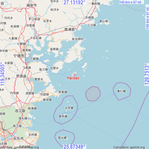
Haidao GPS coordinates[2]
26° 30' 15.948" North, 120° 2' 53.412" East
| Map corner | latitude | longitude |
|---|---|---|
| Upper-left | 27.13192°, | 119.34505° |
| Center: | 26.50443°, | 120.04817° |
| Lower-right: | 25.87349°, | 120.7513° |
| Map W x H: | 139.9×139.9 km | = 86.9×86.9mi |
| max Lat: | 53.31946° ⇑80.5% North |
| Haidao: | 26.50443° |
| min Lat: | ⇓19.5% South 18.22056° |
| min Long | Haidao | max Long |
| 75.07348° | 120.04817° | 134.28917° |
| W 82.2%⇐ | ⇒17.8% E |
Elevation
Elevation of Haidao is 16 m = 52 ft, and this is 468.8 m = 1538 ft below average elevation for this country.
| Max E: |
5622 m = 18445 ft | 84.9% |
| Avg. | 484.8 m = 1591 ft | |
| Haidao | 16 m = 52 ft | |
Min E: |
-3 m = -10 ft | 15.1% |
See also: China elevation on elevation.city.
Geographical zone
Haidao is located in North temperate zone (between Tropic of Cancer and the Arctic Circle). Distance of this Northern Tropic circle is 341.1 km =211.9 mi to South.| Distance of | km | miles | from Haidao |
|---|---|---|---|
| North Pole | 7060 | 4386.9 | to North |
| Arctic Circle | 4454.2 | 2767.7 | to North |
| Tropic Cancer | 341.1 | 211.9 | to South |
| Equator | 2947 | 1831.2 | to South |


Nearby cities:
15 places around Haidao: (largest is in red/bold)
• Ankai
27.5 km =17.1 mi,  228°
228°
• Changchun
24.9 km =15.5 mi,  358°
358°
• Dinghaicun
35.8 km =22.2 mi, 225°
• Dongchongcun
21.8 km =13.5 mi,  280°
280°
• Huangqi
25.9 km =16.1 mi,  219°
219°
• Jianjiang
29.6 km =18.4 mi, 279°
• Kengyuan
33.6 km =20.9 mi,  237°
237°
• Lian’aocun
26.8 km =16.7 mi,  256°
256°
• Shajiang
32 km =19.9 mi,  345°
345°
• Songqi
40.6 km =25.2 mi,  291°
291°
• Tailu
19.7 km =12.2 mi,  214°
214°
• Xiagong
28.6 km =17.8 mi, 241°
• Xiahu
15.4 km =9.6 mi,  319°
319°
• Xiaocheng
35.1 km =21.8 mi, 228°
• Xinan
30.7 km =19.1 mi, 321°
Sources, notices
• [Note1] Compared only with cities in China existing in our database
• [Src1] Map data: © OpenStreetMap contributors (CC-BY-SA)
• [Src2] Other city data from geonames.org with taken over terms of usage.
• [Src3] Geographical zone / Annual Mean Temperature by Robert A. Rohde @ Wikipedia
