Xingzi geodata
Xingzi (Guangdong) is a seat of a fourth-order administrative division; located in China in Asia/Shanghai (GMT+8) time zone. In our database, there are 1268 cities with bigger population. Compared to other cities in China, 86.4% of cities are located further ↑North; 59.8% of cities are located further →East and 55.2% of cities have higher elevation than Xingzi. Note1


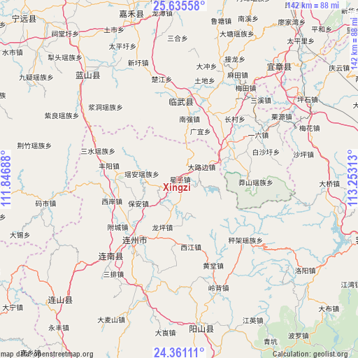
Xingzi GPS coordinates[2]
25° 0' 0" North, 112° 33' 0" East
| Map corner | latitude | longitude |
|---|---|---|
| Upper-left | 25.63558°, | 111.84688° |
| Center: | 25°, | 112.55° |
| Lower-right: | 24.36111°, | 113.25313° |
| Map W x H: | 141.7×141.7 km | = 88×88mi |
| max Lat: | 53.31946° ⇑86.4% North |
| Xingzi: | 25° |
| min Lat: | ⇓13.6% South 18.22056° |
| min Long | Xingzi | max Long |
| 75.07348° | 112.55° | 134.28917° |
| W 40.2%⇐ | ⇒59.8% E |
Elevation
Elevation of Xingzi is 130 m = 427 ft, and this is 354.8 m = 1164 ft below average elevation for this country.
| Max E: |
5622 m = 18445 ft | 55.2% |
| Avg. | 484.8 m = 1591 ft | |
| Xingzi | 130 m = 427 ft | |
Min E: |
-3 m = -10 ft | 44.8% |
See also: China elevation on elevation.city.
Geographical zone
Xingzi is located in North temperate zone (between Tropic of Cancer and the Arctic Circle). Distance of this Northern Tropic circle is 173.8 km =108 mi to South.| Distance of | km | miles | from Xingzi |
|---|---|---|---|
| North Pole | 7227.3 | 4490.8 | to North |
| Arctic Circle | 4621.4 | 2871.6 | to North |
| Tropic Cancer | 173.8 | 108 | to South |
| Equator | 2779.7 | 1727.2 | to South |


Nearby cities:
15 places around Xingzi: (largest is in red/bold)
• Bao’an
18.9 km =11.7 mi,  240°
240°
• Chengjia
35.8 km =22.2 mi,  135°
135°
• Dalubian
7.7 km =4.8 mi,  66°
66°
• Dongbei
25.6 km =15.9 mi,  267°
267°
• Fengyang
28.4 km =17.6 mi,  281°
281°
• Huangben
36.8 km =22.9 mi,  158°
158°
• Lianzhou
30.2 km =18.8 mi,  216°
216°
• Linwu Chengguanzhen
25.9 km =16.1 mi,  357°
357°
• Longping
21.2 km =13.2 mi,  200°
200°
• Sanjiang
40.4 km =25.1 mi, 219°
• Sanshui
34 km =21.1 mi,  289°
289°
• Shantang
9.7 km =6 mi,  30°
30°
• Xijiang
27.5 km =17.1 mi,  172°
172°
• Xi’an
27.8 km =17.3 mi,  251°
251°
• Yao’an
14.9 km =9.3 mi, 278°
Sources, notices
• [Note1] Compared only with cities in China existing in our database
• [Src1] Map data: © OpenStreetMap contributors (CC-BY-SA)
• [Src2] Other city data from geonames.org with taken over terms of usage.
• [Src3] Geographical zone / Annual Mean Temperature by Robert A. Rohde @ Wikipedia
