Dezhou geodata
Dezhou (Sichuan) is a seat of a third-order administrative division; located in China in Asia/Shanghai (GMT+8) time zone. In our database, there are 1268 cities with bigger population. Compared to other cities in China, 77% of cities are located further ↑North; 92.6% of cities are located further →East and 90.4% of cities have lower elevation than Dezhou. Note1


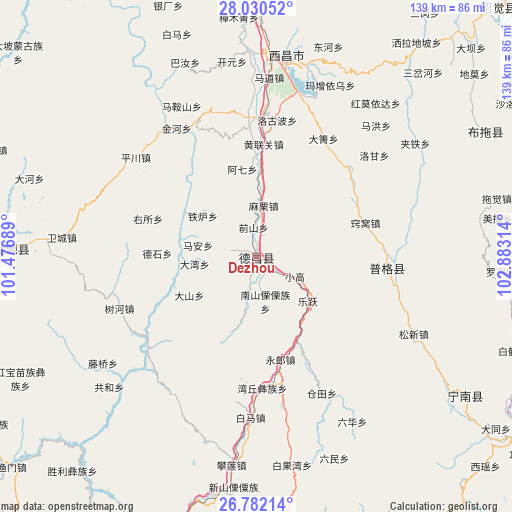
Dezhou GPS coordinates[2]
27° 24' 29.124" North, 102° 10' 48.036" East
| Map corner | latitude | longitude |
|---|---|---|
| Upper-left | 28.03052°, | 101.47689° |
| Center: | 27.40809°, | 102.18001° |
| Lower-right: | 26.78214°, | 102.88314° |
| Map W x H: | 138.8×138.8 km | = 86.2×86.2mi |
| max Lat: | 53.31946° ⇑77% North |
| Dezhou: | 27.40809° |
| min Lat: | ⇓23% South 18.22056° |
| min Long | Dezhou | max Long |
| 75.07348° | 102.18001° | 134.28917° |
| W 7.4%⇐ | ⇒92.6% E |
Elevation
Elevation of Dezhou is 1389 m = 4557 ft, and this is 904.2 m = 2967 ft above average elevation for this country.
| Max E: |
5622 m = 18445 ft | 9.6% |
| Dezhou | 1389 m 4557 ft | |
| Avg. | 484.8 m = 1591 ft | |
Min E: |
-3 m = -10 ft | 90.4% |
See also: China elevation on elevation.city.
Geographical zone
Dezhou is located in North temperate zone (between Tropic of Cancer and the Arctic Circle). Distance of this Northern Tropic circle is 441.6 km =274.4 mi to South.| Distance of | km | miles | from Dezhou |
|---|---|---|---|
| North Pole | 6959.6 | 4324.5 | to North |
| Arctic Circle | 4353.7 | 2705.3 | to North |
| Tropic Cancer | 441.6 | 274.4 | to South |
| Equator | 3047.5 | 1893.6 | to South |


Nearby cities:
15 places around Dezhou: (largest is in red/bold)
• Huidong
94.2 km =58.5 mi,  155°
155°
• Huili Chengguanzhen
83.1 km =51.6 mi,  175°
175°
• Jiecun
79.5 km =49.4 mi,  94°
94°
• Panlian
58.3 km =36.2 mi,  186°
186°
• Panzhihua
102.6 km =63.8 mi,  206°
206°
• Pisha
68.3 km =42.4 mi,  123°
123°
• Puji
35.8 km =22.2 mi, 94°
• Shanjiao
88.2 km =54.8 mi,  96°
96°
• Shuigou
99.8 km =62 mi, 121°
• Temuli
70.3 km =43.7 mi,  61°
61°
• Tongzilin
85.2 km =52.9 mi,  202°
202°
• Xichang
54.9 km =34.1 mi,  8°
8°
• Xincheng
93.8 km =58.3 mi,  44°
44°
• Xinhua
94.3 km =58.6 mi,  127°
127°
• Yanjing
66.2 km =41.1 mi,  271°
271°
Sources, notices
• [Note1] Compared only with cities in China existing in our database
• [Src1] Map data: © OpenStreetMap contributors (CC-BY-SA)
• [Src2] Other city data from geonames.org with taken over terms of usage.
• [Src3] Geographical zone / Annual Mean Temperature by Robert A. Rohde @ Wikipedia
