Puji geodata
Puji (Sichuan) is a seat of a third-order administrative division; located in China in Asia/Shanghai (GMT+8) time zone. In our database, there are 1268 cities with bigger population. Compared to other cities in China, 77.1% of cities are located further ↑North; 92.2% of cities are located further →East and 90.5% of cities have lower elevation than Puji. Note1


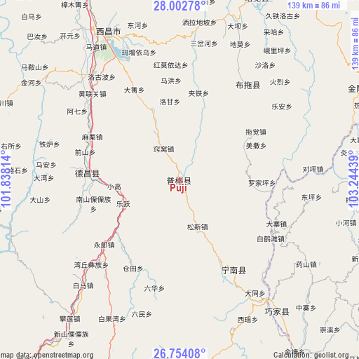
Puji GPS coordinates[2]
27° 22' 48.684" North, 102° 32' 28.536" East
| Map corner | latitude | longitude |
|---|---|---|
| Upper-left | 28.00278°, | 101.83814° |
| Center: | 27.38019°, | 102.54126° |
| Lower-right: | 26.75408°, | 103.24439° |
| Map W x H: | 138.8×138.8 km | = 86.2×86.2mi |
| max Lat: | 53.31946° ⇑77.1% North |
| Puji: | 27.38019° |
| min Lat: | ⇓22.9% South 18.22056° |
| min Long | Puji | max Long |
| 75.07348° | 102.54126° | 134.28917° |
| W 7.8%⇐ | ⇒92.2% E |
Elevation
Elevation of Puji is 1404 m = 4606 ft, and this is 919.2 m = 3016 ft above average elevation for this country.
| Max E: |
5622 m = 18445 ft | 9.5% |
| Puji | 1404 m 4606 ft | |
| Avg. | 484.8 m = 1591 ft | |
Min E: |
-3 m = -10 ft | 90.5% |
See also: China elevation on elevation.city.
Geographical zone
Puji is located in North temperate zone (between Tropic of Cancer and the Arctic Circle). Distance of this Northern Tropic circle is 438.5 km =272.5 mi to South.| Distance of | km | miles | from Puji |
|---|---|---|---|
| North Pole | 6962.7 | 4326.4 | to North |
| Arctic Circle | 4356.8 | 2707.2 | to North |
| Tropic Cancer | 438.5 | 272.5 | to South |
| Equator | 3044.4 | 1891.7 | to South |


Nearby cities:
15 places around Puji: (largest is in red/bold)
• Dezhou
35.8 km =22.2 mi,  274°
274°
• Guji
77.1 km =47.9 mi,  107°
107°
• Jiecun
43.7 km =27.2 mi,  93°
93°
• Jiezi
79.4 km =49.3 mi,  145°
145°
• Laojiezi
82.2 km =51.1 mi,  134°
134°
• Panlian
69.5 km =43.2 mi,  218°
218°
• Pisha
40.5 km =25.2 mi, 148°
• Sanguanzhai
76.9 km =47.8 mi, 113°
• Shanjiao
52.5 km =32.6 mi,  97°
97°
• Shuigou
69.6 km =43.2 mi, 134°
• Temuli
44.9 km =27.9 mi,  35°
35°
• Tiandiba
78.3 km =48.7 mi,  62°
62°
• Xichang
63.6 km =39.5 mi,  334°
334°
• Xincheng
76.6 km =47.6 mi,  22°
22°
• Xinhua
67 km =41.6 mi,  144°
144°
Sources, notices
• [Note1] Compared only with cities in China existing in our database
• [Src1] Map data: © OpenStreetMap contributors (CC-BY-SA)
• [Src2] Other city data from geonames.org with taken over terms of usage.
• [Src3] Geographical zone / Annual Mean Temperature by Robert A. Rohde @ Wikipedia
