Xichang geodata
Xichang (Sichuan) is a seat of a third-order administrative division; located in China in Asia/Shanghai (GMT+8) time zone. With population of 126,787 people, there are 345 cities with bigger population in this country. Compared to other cities in China, 74.7% of cities are located further ↑North; 92.5% of cities are located further →East and 91.9% of cities have lower elevation than Xichang. Note1


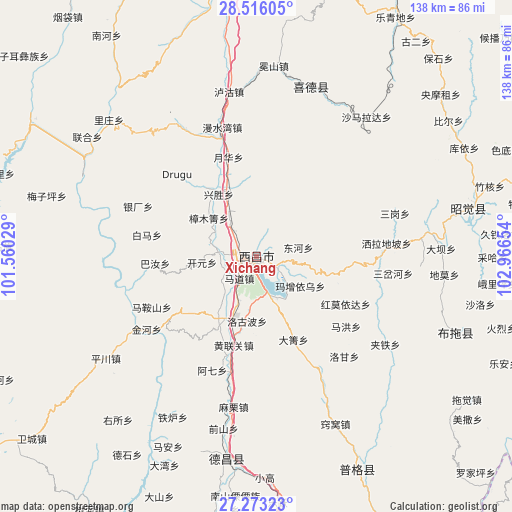
Xichang GPS coordinates[2]
27° 53' 47.112" North, 102° 15' 48.276" East
| Map corner | latitude | longitude |
|---|---|---|
| Upper-left | 28.51605°, | 101.56029° |
| Center: | 27.89642°, | 102.26341° |
| Lower-right: | 27.27323°, | 102.96654° |
| Map W x H: | 138.2×138.2 km | = 85.9×85.9mi |
| max Lat: | 53.31946° ⇑74.7% North |
| Xichang: | 27.89642° |
| min Lat: | ⇓25.3% South 18.22056° |
| min Long | Xichang | max Long |
| 75.07348° | 102.26341° | 134.28917° |
| W 7.5%⇐ | ⇒92.5% E |
Elevation
Elevation of Xichang is 1558 m = 5112 ft, and this is 1073.2 m = 3521 ft above average elevation for this country.
| Max E: |
5622 m = 18445 ft | 8.1% |
| Xichang | 1558 m 5112 ft | |
| Avg. | 484.8 m = 1591 ft | |
Min E: |
-3 m = -10 ft | 91.9% |
See also: Xichang elevation on elevation.city.
Geographical zone
Xichang is located in North temperate zone (between Tropic of Cancer and the Arctic Circle). Distance of this Northern Tropic circle is 495.9 km =308.1 mi to South.| Distance of | km | miles | from Xichang |
|---|---|---|---|
| North Pole | 6905.3 | 4290.8 | to North |
| Arctic Circle | 4299.4 | 2671.5 | to North |
| Tropic Cancer | 495.9 | 308.1 | to South |
| Equator | 3101.8 | 1927.4 | to South |


Nearby cities:
15 places around Xichang: (largest is in red/bold)
• Chengxiang
73.6 km =45.7 mi,  352°
352°
• Dezhou
54.9 km =34.1 mi,  188°
188°
• Guangming
48.3 km =30 mi,  17°
17°
• Jiecun
92.9 km =57.7 mi,  130°
130°
• Panlian
113.2 km =70.3 mi, 187°
• Pisha
104 km =64.6 mi,  152°
152°
• Puji
63.6 km =39.5 mi, 154°
• Qiaowa
96.9 km =60.2 mi,  272°
272°
• Shanjiao
101.8 km =63.3 mi, 128°
• Temuli
57.5 km =35.7 mi,  111°
111°
• Tiandiba
99.2 km =61.6 mi,  102°
102°
• Wanhechang
123.2 km =76.6 mi, 96°
• Xincheng
58.4 km =36.3 mi,  76°
76°
• Yanjing
90.7 km =56.4 mi,  234°
234°
• Yuecheng
86.3 km =53.6 mi, 16°
Sources, notices
• [Note1] Compared only with cities in China existing in our database
• [Src1] Map data: © OpenStreetMap contributors (CC-BY-SA)
• [Src2] Other city data from geonames.org with taken over terms of usage.
• [Src3] Geographical zone / Annual Mean Temperature by Robert A. Rohde @ Wikipedia
